|
Historical Railway Photograph Gallery 651-700 |
|||||||||
| 601-650 <- |
Photos 651-700 |
-> 701-750 | |||||||
| Photo | ELR | Branch | Subject | Location | M | C | Elev'n | Date | Time |
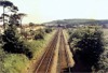
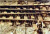
 bpm00651.jpg |
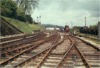
SWM | Severn Tunnel junction & Fishguard Harbour | Reciprocal view of bpm00650 frame | East end of Stormy up goods loop | 194 | 36 | East | 18-May-91 | 15.28 |
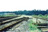
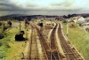 bpm00652.jpg |
CAM | Cardiff (Bute Road) & Merthyr | Merthyr Goods sidings & Brandy Bridge signal box. The left-hand lines led to Plymouth St goods dep�t and the Ynysfach branch. The severed siding running across the river bridge, led to the Willows wireworks. In the distance can be seen the embankment carrying the lines to Ponsticill or Neath via Gelli Tarw junction. | Brandy Bridge junction (also 0M-00C mileage) |
23 0 |
62 00 |
SE | July-1963 | |
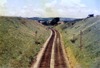
 bpm00653.jpg |
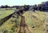
MER | Gelli Tarw junction & Merthyr | Single line from Merthyr tunnel looking towards Merthyr and showing groundframe point rodding and single-throw trap in siding after branch closure. The gate locates the former Gethin branch which ran towards Cefn Coed | North-east of east portal of Merthyr tunnel | ~5 | 17 | SW | ||
 bpm00654.jpg |
MER | Gelli Tarw junction & Merthyr | View looking towards Merthyr showing out-of-use double to single line junction to single line Merthyr branch and single Quakers' Yard & Merthyr (Abercanaid) branch | South-west of Rhydycar Jct signal box |
5 6 |
39 04 |
SW | ||
 bpm00655.jpg |
MER | Gelli Tarw junction & Merthyr | Stone-walled overbridge north-east of east portal of Merthyr tunnel | Near site of former Merthyr tunnel loop junction | ~4 | 78 | SW | ||
 bpm00656.jpg |
|||||||||
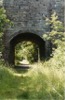
 bpm00657.jpg |
CRY | Coryton | Headshunt at curtailed ex Cardiff railway line at Coryton. After the introduction of diesel multiple units in 1958, the headshunt was not used | Old A470 road overbridge, Coryton, Cardiff | 2 | 58 | East | ||
 bpm00658.jpg |
CRY | Coryton | Coryton halt as viewed from old A470 road overbridge. Run-around loop was still in situ but out of use after introduction of diesel multiple units | Old A470 road overbridge, Coryton, Cardiff | 2 | 58 | West | ||
 bpm00659.jpg |
RAD | Radyr | Looking north-west from Fairwater Rd overbridge towards Radyr. The new City line Fairwater station is now located here | Fairwater Rd overbridge, Cardiff | 2 | 52 | SE | ||
 bpm00660.jpg |
RAD | Radyr | Looking south-east towards Waun Gron and Leckwith from Fairwater Rd overbridge, Fairwater. The former Ely Paper Mills is seen in the distance | Fairwater Rd overbridge, Cardiff | 2 | 52 | NW | ||
 bpm00661.jpg |
RAD | Radyr | Looking north towards the Warren where the new City line station known as Danescourt has been constructed | A4119 Llantrisant Rd overbridge, south of new Danescourt station site and west of Llandaff | 3 | 09 | South | ||
 bpm00662.jpg |
SWM | Severn Tunnel Jct & Fishguard Harbour | Llantrisant station, east end, showing headshunt and siding for the former Cowbridge line (Aberthaw branch) | B4270 Road overbridge at former Llantrisant station (Brynsadler-Pontyclun boundary) | 181 | 31 | West | ||
 bpm00663.jpg |
SWM | Severn Tunnel Jct & Fishguard Harbour | Former Llantrisant station layout showing start of the Aberthaw branch (for Cowbridge) the 0M-00C datum at the facing points. The Llantrisant East signal box is seen in the distance and the South Wales Main lines run straight ahead. The station was subsequently completely removed and later, new platforms constructed for the station now known as Pontyclun | Former Llantrisant station (now Pontyclun) | 181 | 32 | East | ||
 bpm00664.jpg |
ATW | Llantrisant Jct & Aberthaw Low Level | View of junction at former Llanharry halt showing junction to Llanharry iron ore mine. This was originally a passenger & freight line and so the points bore a facing point lock. The 2-lever groundframe released by Annetts key, can be seen beyond the platform | Former Llanharry halt | 1 | 30.75 | South | ||
 bpm00665.jpg |
Spare | ||||||||
 bpm00666.jpg |
|||||||||
 bpm00667.jpg |
BRY | Cardiff (General) & Barry Pier | New work, near Llandough sidings in preparation for abolition of single line bowspring bridge seen on left | Ely river bridge | 1 | 52 | South | 14-May-66 | 11.49 |
 bpm00668.jpg |
BRY | Cardiff (General) & Barry Pier | Basic re-alignment of up main, near Llandough sidings, in preparation for removal of bow string bridge over river Ely | Ely river bridge | 1 | 49 | North | 14-May-66 | 11.49 |
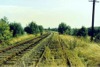
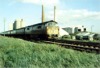 bpm00669.jpg |
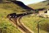
VOG | Vale of Glamorgan | Western diesel-hydraulic loco' and down passenger train on a diversion via the Vale of Glamorgan line | Rhoose | 3 | 18 | West | ||
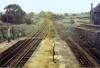
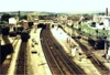 bpm00670.jpg |
SWM | Severn Tunnel Jct & Fishguard Harbour | Station view from east end | Road overbridge at east end of Bridgend station | 190 | 37 | East | 20-Jun-64 | 14.03 |
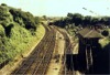 bpm00671.jpg |
SWM | Severn Tunnel Jct & Fishguard Harbour | Vale of Glamorgan line junction and signal box | Bridgend East | 190 | 37 | West | 20-Jun-64 | 14.04 |
 bpm00672.jpg |
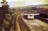
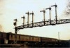
CAM | Cardiff (Bute Road) & Merthyr | 7-doll signal gantry with loop line signals and route indicator | Cathays | West | 1963 | |||
 bpm00673.jpg |
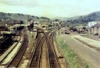
CAM | Cardiff (Bute Road) & Merthyr | Taffs Well station and Walnut Tree junction when fully operational. The double-line to the right was the main freight link for most of the Barry- and Cardiff-bound coal traffic from the Rhymney valley via Penrhos until closure and lifting by 1990. Occasionally that branch saw passenger traffic when engineering possessions took place for Caerphilly tunnel engineering maintenance | Walnut Tree junction, Taffs Well |
7 12 |
17 03 |
SE | ||
 bpm00674.jpg |
NAN | Nantgarw | Skew Bridge over old A471 road (Now removed) | Glanyllyn | 5 | 65.25 | NW | ||
 bpm00675.jpg |
NAN | Nantgarw | Skew Bridge over old A471 road (Now removed) | Glanyllyn | 5 | 65.25 | SE | ||
 bpm00676.jpg |
Spare | ||||||||
 bpm00677.jpg |
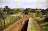
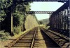
LTO | Waterhall junction & Common Branch junction | View of single line from road bridge (Line closed between here & Creigiau Quarry in 1964) | Fairwater | West | ||||
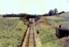 bpm00678.jpg |
LTO | Waterhall junction & Common Branch junction | View of single line from road bridge (Line closed between here & Creigiau Quarry in 1964) | Fairwater | East | ||||
 bpm00679.jpg |
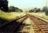
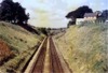
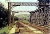
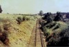
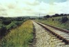
NAB | Neath & Brecon | View of station and track after closure | Defynog & Sennybridge station | 24 | 42 | South | ||
 bpm00680.jpg |
NAB | Neath & Brecon | Looking towards Cray from a point just south of Devynock & Sennybridge station | Defynog | 24 | 22 | North | ||
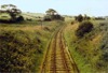
 bpm00681.jpg |
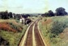
NAB | Neath & Brecon | View of single line after closure, looking towards Cray | Cray/Defynog | North | ||||
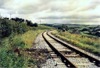 bpm00682.jpg |
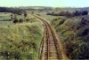
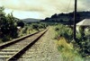
NAB | Neath & Brecon | View of single line after closure, looking towards Defynog | Cray/Defynog | South | ||||
 bpm00683.jpg |
VOG | Vale of Glamorgan | Barry Sidings layout when in full use | A4050 St.Nicholas Road overbridge, Barry | 0 | 16 | North | ||
 bpm00684.jpg |
CAN | Carmarthen & Newcastle Emlyn | Unclassified road bridge over lifted single line Newcastle Emlyn branch. The bridge adjoins the river Teifi road overbridge to the left of the photo and the camera point is at the former Pentrecwrt halt where the platform was on the right of the trackbed | Trackbed at former Pentrecwrt halt between Henllan and Pencader | 265 | 48 | East | ||
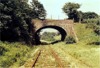
 bpm00685.jpg |
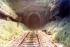
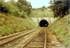
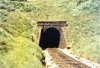
MER | Gelli Tarw junction & Merthyr | South-west portal of 2497-yard Merthyr tunnel (From 3M-37C to 4M-01C) | South-west portal of Merthyr tunnel | 3 | 38.5 | South | ||
 bpm00686.jpg |
MER | Gelli Tarw junction & Merthyr | Looking south-west from just inside west portal of Merthyr tunnel after closure of branch | West portal of Merthyr tunnel | East | ||||
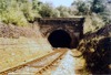
 bpm00687.jpg |
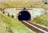
VON | Neath (General) & Pontypool Road | Internal view from west portal of single line 703-yard Quakers' Yard tunnel (From 16M-09C to 16M-41C) | Quakers' Yard tunnel, west portal | 16 | 39 | East | ||
 bpm00688.jpg |
BRY | Cardiff (General) & Barry Pier | Permanent way layout immediately north of Cogan junction when remodelling of the permanent way had been commenced | Between Cogan junction & Llandough signal boxes | 2 | 20 | East | 14-May-66 | |
| bpm00689.jpg | SPARE | ||||||||
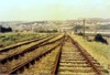
 bpm00690.jpg |
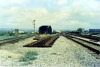
VOG | Vale of Glamorgan | 545-yard Porthkerry No.1 tunnel, east portal (From 0M-53C to 0M-77C) | Barry Sidings | 0 | 47 | East | ||
 bpm00691.jpg |
BRY | Cardiff (General) & Barry Pier | South-west portal of 222-yard Cogan tunnel (From 2M-75C to 3M-05C) | Between Eastbrook & Cogan (Camera at 3M-07C) |
2 3 |
75 05 |
SW | ||
 bpm00692.jpg |
BRY | Cardiff (General) & Barry Pier | Overhead view of Cogan sidings signal box and junction of up & down main lines with relief lines. The down relief line was not used at this time and the down relief home signal had been removed. Its post is seen lying on the ballast beyond the down relief traps | Above east end of Cogan tunnel | 2 | 78 | SW | ||
 bpm00693.jpg |
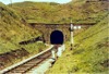
BAL | Bridgend & Abergwynfi | South portal of 1595-yard single-line Cymmer tunnel (From 10M-17C to 11M-10C). The far end is just visible | Immediately north of former Caerau station (Camera st 10M-15.5C) |
10 11 |
17 10 |
SE | 20-Jun-64 | 15.09 |
 bpm00694.jpg |
RSB | Rhondda & Swansea Bay | South-west portal of single-line 3443-yard Rhondda tunnel (From 1M-45C to 3M-41C) showing down home signal and temporary speed restriction board (which became "permanent" due to subsidence in the tunnel). Cutting & portal now completely backfilled as is North-east end but drainage culvert exists at Blaenycwm end | Immediately north-east of former Blaengwynfi station (Camera at 3M-43C) |
1 3 |
45 41 |
SW | 20-Jun-64 | 15.38 |
 bpm00695.jpg |
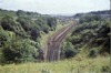
BAL | Bridgend & Abergwynfi | Cymmer sidings showing single line over Cymmer Viaduct (110-yards) to Glyncorrwg and single line to Cymmer Afan station & Treherbert. None of this system survives but the viaduct still stands although with no decking | Hairpin road bend (A4117) over top of Cymmer tunnel, sealed north portal. | 11 | 10 | East | 20-Jun-64 | 15.28 |
 bpm00696.jpg |
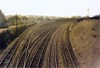
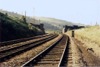
CAR | Cardiff (Stonefield Jct) & Rhymney | Up & down Rhymney lines with one down relief line after the up relief line had been lifted | Just south of former Llanbradach viaduct, Energlyn | 10 | 12 | SE | ||
 bpm00697.jpg |
BRY | Cardiff (General) & Barry Pier | Double inside slip. Plan view on switch ends | Barry Island East | 8 | 75 | North | ||
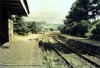
 bpm00698.jpg |
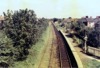
CRY | Coryton | View of Whitchurch station when double lines were still installed | Whitchurch | SW | ||||
 bpm00699.jpg |
AAM | Ashchurch & Malvern | Looking towards Tewkesbury from a point just east of the east portal of the Mythe tunnel, showing abandoned double line | The Mythe, north of Tewkesbury | 2 | 36 | West | ||
 bpm00700.jpg |
PTN | Peterston | Abandoned Cutting (now filled in and fields commoned), remnant of the former Barry Railway single line link to Peterston from Drope junction on the Wenvoe-Pontypridd line | Near St.Georges | 1 | 37 | West | ||
| 601-650 <- |
Photos 651-700 |
-> 701-750 | |||||||
|
Date Last Revised:November 30, 2009 |
|||||||||