|
Historical Railway Photograph Gallery 2801-2850 |
|||||||||
|
Photos 2801-2850 |
|||||||||
| Photo | ELR | Branch | Subject | Location | M | C | Elev'n | Date | Time |
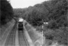
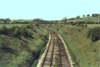
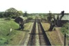
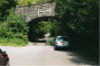
bpm02801.jpg |
SWM RSB |
Severn Tunnel Jct & Fishguard
Harbour Rhondda & Swansea Bay |
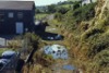
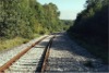
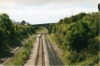
Looking south towards Baglan, at the Briton Ferry sidings fan and through down goods loop line | Ynysmaerdy Rd overbridge south of Court Sart junction |
206 17 |
40 67 |
North | 06-Sep-89 | 12.25 |
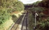
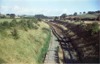
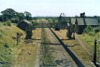
 bpm02802.jpg |
SWM RSB |
Severn Tunnel Jct & Fishguard
Harbour Rhondda & Swansea Bay |
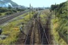
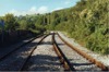
Looking south towards Baglan, at the up & down South Wales main lines and the Briton Ferry sidings fan. The single line on the left is the former R&SB line which is the up flying loop from the Swansea District lines | Ynysmaerdy Rd overbridge south of Court Sart junction |
206 17 |
40 67 |
North | 06-Sep-89 | 12.25� |
 bpm02803.jpg |
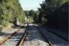
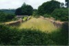
BJR | Bassaleg Jct & Rhymney | View of barren trackbed after abolition of Bedwas Colliery and sidings. The Bedwas Colliery North signal box stood on the left, 2.5 chains beyond the bridge from where this photo was taken (See frame bpm00196 for previous record) | Dawlyn Rd overbridge west of former Bedwas Colliery North signal box | 7 | 59 | West | 24-Sep-89 | 14.10 |
 bpm02804.jpg |
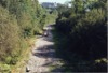
BJR | Bassaleg Jct & Rhymney | Trackbed of former tight curve at road overbridge immediately east of Machen station site. A public footbridge is visible in the cutting beyond | Machen station road overbridge | 4 | 78.5 | West | 24-Sep-89 | 14.30 |
 bpm02805.jpg |
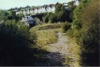
BJR | Bassaleg Jct & Rhymney | Reciprocal view of frame bpm02804.jpg showing former Machen station site | Machen station road overbridge | 4 | 79 | East | 24-Sep-89 | 14.30 |
 bpm02806.jpg |
BJR | Bassaleg Jct & Rhymney | View of headshunt and trackbed at end of curtailed BJR branch, east of Machen | Public footbridge east of former Machen station | 4 | 72.25 | West | 24-Sep-89 | 14.40 |
 bpm02807.jpg |
BJR | Bassaleg Jct & Rhymney | Looking towards site of former Machen station which stood immediately after the road overbridge shown | Public footbridge east of former Machen station | 4 | 72.25 | East | 24-Sep-89 | 14.40 |
 bpm02808.jpg |
BJR | Bassaleg Jct & Rhymney | Looking towards the headshunt buffer stop at the western extremity of the curtailed BJR branch, east of Machen. | Headshunt buffer stop east of Machen | 4 | 68 | East | 24-Sep-89 | 14.43 |
 bpm02809.jpg |
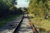
BJR | Bassaleg Jct & Rhymney | The little used single line running to the buffer stop east of Machen on the curtailed BJR branch | Between Machen quarry & Machen | 4 | 67 | West | 24-Sep-89 | 14.45 |
 bpm02810.jpg |
BJR | Bassaleg Jct & Rhymney | The quarry line (left) and the through line(right), west of Machen quarry. Machen quarry inlet groundframe is located at the single line junction at 4M-45C | Just east of Machen quarry inlet groundframe | 4 | 43 | East | 24-Sep-89 | 14.55 |
 bpm02811.jpg |
BJR | Bassaleg Jct & Rhymney | The quarry line (right) and the through line(left), west of Machen quarry. The 4.5 milepost is seen on the left, (down) side of the line | West of Machen quarry | 4 | 41 | West | 24-Sep-89 | 14.56 |
 bpm02812.jpg |
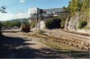
BJR | Bassaleg Jct & Rhymney | Looking towards the former Lime Kilns overbridge and the stone loading point at Machen quarry. The former up & down main lines pass under the overbridge on the right of the scene | Machen quarry | 4 | 16 | East | 24-Sep-89 | 15.04 |
 bpm02813.jpg |
CTD | Cadoxton South jct & Trehafod jct | Pannier tank loco' 9622 running light engine from Tonteg to Canton and about to pass the down distant at caution, for Creigiau signal box. Note the aqueduct in the cutting and the fogman's hut to the rear of the distant signal. The prize state of the track and cesses is to be appreciated | Unclassified road overbridge north of Creigiau | 9 | 43 | South | 1961 | |
 bpm02814.jpg |
CTD | Cadoxton South jct & Trehafod jct | The same view as that in frame bpm02813.jpg after abandonment of the line between Cadoxton South jct & Tonteg jct | Unclassified road overbridge north of Creigiau | 9 | 43 | South | ||
 bpm02815.jpg |
CTD | Cadoxton South jct & Trehafod jct | The same view as that in frame bpm02813.jpg after complete removal of the line between Cadoxton South jct & Tonteg jct | Unclassified road overbridge north of Creigiau | 9 | 43 | South | ||
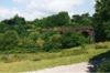
 bpm02816.jpg |
CTD | Cadoxton South jct & Trehafod jct | Short inter-field access viaduct just north of Wenvoe station when line was still in full use. The down distant signal is just visible beyond the platelayers' hut seen beyond the centre arch (Black & white record) | On track, north of Wenvoe station | 2 | ~74 | South | 1960 | |
 bpm02817.jpg |
CTD | Cadoxton South jct & Trehafod jct | Looking towards short inter-field viaduct from road overbridge at north end of Wenvoe station after abandonment of line | Station Rd overbridge at north end of Wenvoe station | 2 | 68 | South | ||
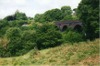
 bpm02818.jpg |
CTD | Cadoxton South jct & Trehafod jct | Looking towards short inter-field viaduct from road overbridge at north end of Wenvoe station during recovery of track by contractor. Due to problems with the track in the Wenvoe tunnel north of the cutting, the up line was slued into the down line here | Station Rd overbridge at north end of Wenvoe station | 2 | 68 | South | ||
 bpm02819.jpg |
CTD | Cadoxton South jct & Trehafod jct | Looking towards short inter-field viaduct from road overbridge at north end of Wenvoe station after recovery of rails and sleepers north of this point, by contractor | Station Rd overbridge at north end of Wenvoe station | 2 | 68 | South | ||
 bpm02820.jpg |
CTD | Cadoxton South jct & Trehafod jct | Looking towards short inter-field viaduct from road overbridge at north end of Wenvoe station 33 years after the track was lifted. | Station Rd overbridge at north end of Wenvoe station | 2 | 68 | South | ||
|
bpm02821.jpg |
CTD | Cadoxton South jct & Trehafod jct | Reserved (Wenvoe station) | Between platforms of abandoned Wenvoe station | 2 | North | |||
 bpm02822.jpg |
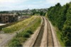
CTD | Cadoxton South jct & Trehafod jct | Wenvoe station after closure and abandonment of line. Note that some of the track on the incline on the left is still visible. This was originally a long siding which ran to the Alps quarry half a mile north of here. It crossed the road at a level crossing alongside the bridge from whence this photo' was taken | Station Rd overbridge at north end of Wenvoe station | 2 | 68 | North | ||
 bpm02823.jpg |
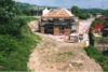
CTD | Cadoxton South jct & Trehafod jct | Wenvoe station during recovery of out-of-use track by contractor | Station Rd overbridge at north end of Wenvoe station | 2 | 68 | North | ||
| bpm02824.jpg | CTD | Cadoxton South jct & Trehafod jct | Spare | Wenvoe station | 2 | 68 | |||
 bpm02825.jpg |
CTD | Cadoxton South jct & Trehafod jct | Wenvoe station used as a private dwelling and showing purpose-built structures and ponded area between platforms | Wenvoe station | 2 | 68 | North | 13-May-89 | 15.52 |
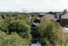
 bpm02826.jpg |
BHB | Bristol Harbour | Remaining section of Redcliffe viaduct structure, southern extremity of remaining arched structure | Redcliffe Way, south-west of Bristol Temple Meads station | 118 | ~42 | South | ||
 bpm02827.jpg |
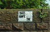
ATW | Aberthaw | British Railways Board bridge inspection marking on wall of road overbridge No.32 near former St. Hilary halt, on lifted Aberthaw branch. The ELR ref. should read 'ATW' and was corrected in 2006 | Unclassified road overbridge south-west of St. Hilary | 7 | 11.75 | West | 16-May-05 | 16.30 |
 bpm02828.jpg |
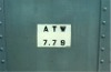
ATW | Aberthaw | British Railways Board bridge inspection marking on steel side of Kingsland road overbridge, No.34 of lifted Aberthaw branch | Just north of privately occupied former St.Mary Church station, south of Cowbridge | 7 | 79 | North | 16-May-05 | 16.40 |
 bpm02829.jpg |
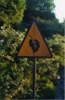
SWM | Severn Tunnel Jct & Fishguard Harbour | Warning sign of poor adhesion due to leaf fall. The display can be folded in half when hazard does not exist | West end of Tremains area, east of Bridgend | East | 18-Jun-05 | 20.45 | ||
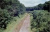
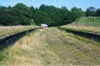
 bpm02830.jpg |
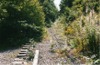
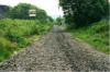
LTR | Mwyndy jct & Tonteg jct | Trackbed of former Llantrisant Railway between Mwyndy junction and Cwm colliery. The Costain concrete sleepers bore 113A flat-bottom rails which it is rumoured, were stolen from the mothballed line | Just north of Cross Inn and south of Common Branch junction | ~1 | 60 | North | 01-Sep-04 | 13.50 |
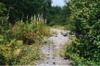 bpm02831.jpg |
LTR | Mwyndy jct & Tonteg jct | Trackbed of former Llantrisant Railway between Mwyndy junction and Cwm colliery. The Costain concrete sleepers bore 113A flat-bottom rails which it is rumoured, were stolen from the mothballed line | Just north of Cross Inn and south of Common Branch junction | ~1 | 60 | South | 01-Sep-04 | 13.50 |
 bpm02832.jpg |
PTP | Port Talbot & Pontyrhyl | The trackbed of the former Port Talbot Railway, east of Pontrhydycyff viaduct and looking towards Lletty Brongu station, upline | South of Pontrhydycyff viaduct | 10 | 30 | West | ||
 bpm02833.jpg |
PTP | Port Talbot & Pontyrhyl | View looking towards east end of Pontrhydycyff viaduct. The handrailings either side of the trackbed are aligned with a rail overbridge which originally spanned an incline to Lletty Brongu colliery to the north | Immediately east of Pontrhydycyff viaduct, Lletty Brongu | 10 | 30 | SE | ||
 bpm02834.jpg |
PTP | Port Talbot & Pontyrhyl | Looking south-east from east end of Pontrhydycyff viaduct with sleeper indentations still visible on a rail overbridge which passed over a former incline to Lletty Brongu colliery | Immediately east of Pontrhydycyff viaduct, Lletty Brongu | 10 | 28.5 | NW | ||
 bpm02835.jpg |
PTP | Port Talbot & Pontyrhyl | Looking west along 132yd single line Pontrhydycyff (Lletty Brongu) brick viaduct, south of Garth & Maesteg | Pontrhydycyff (Lletty Brongu) viaduct | 10 | 23 | East | ||
 bpm02836.jpg |
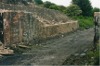
PTP | Port Talbot & Pontyrhyl | Southerly view of Pontrhydycyff brick viaduct showing poor state of trackside walling due to vandalism | Farm track south-east of Lletty Brongu viaduct | 10 | 27 | South | ||
 bpm02837.jpg |
PTP | Port Talbot & Pontyrhyl | South-easterly view of Pontrhydycyff viaduct, highlighting vandalised trackside walling | Pontrhydycyff (Lletty Brongu) viaduct | 10 | 27 | SE | ||
 bpm02838.jpg |
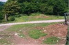
LTR | Mwyndy jct & Tonteg jct | A new property being constructed in the fork of the Llantrisant railway and the Brofiscin branch east of Talbot green, at Cross Inn. The single line to Cwm colliery is buried under the vegetation but part of the curve can be seen just to the left of the house | Maesaraul junction on the former Mwyndy jct to Tonteg junction line | 1 | 04 | West | ||
 bpm02839.jpg |
BAL | Bridgend & Abergwynfi | Looking downline from road overbridge immediately south of former Llangynwyd station | No.28, Unclassified road overbridge immediately east of former Llangynwyd station, Llynfi valley | 6 | 20.25 | North | ||
 bpm02840.jpg |
BAL | Bridgend & Abergwynfi | Looking towards site of Llangynwyd station after relaying the single line using all steel sleepers | No.28, Unclassified road overbridge immediately east of former Llangynwyd station, Llynfi valley | 6 | 20.25 | South | ||
 bpm02841.jpg |
BAL PTP |
Bridgend & Abergwynfi Port Talbot & Pontyrhyl | The site of the rail overbridge which carried the lines from Duffryn Yard, Port Talbot to Cwmdu and Pontyrhyl. Evidence of widening is seen where the brickwork changes in style. The bridge had only just been removed prior to this photo' record | No.40 Rail overbridge of Bridgend & Abergwynfi line at intersection with former Port Talbot & Pontyrhyl branch (Overhead) |
8 7 |
34 70 |
NW | ||
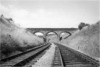
 bpm02842.jpg |
BAL | Bridgend & Abergwynfi | Looking down the then, recently lifted Bridgend & Abergwynfi single line section between Maesteg and Nantyffyllon towards the then just-removed PTR rail overbridge south of former Llynfi junction. The down fixed distant marker had not been removed | South of former Llynfi junction | 8 | 38.5 | North | ||
 bpm02843.jpg |
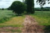
GCT | Grange Court & Hereford | View looking along trackbed towards Micheldean from an unclassified road overbridge just east of former Weston-under-Penyard halt | Unclassified road overbridge adjacent to former Weston-under-Penyard halt | 130 | 11 | West | 12.57 | |
 bpm02844.jpg |
GCT | Grange Court & Hereford | View looking along levelled trackbed in vicinity of former Weston-under-Penyard halt between Ross-on-Wye and Micheldean Road | Unclassified road overbridge adjacent to former Weston-under-Penyard halt | 130 | 11 | East | 12.57 | |
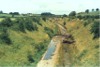
 bpm02845.jpg |
LTO | Waterhall jct & Common Branch jct | Skew rail overbridge which carried the Waterhall Jct to Common Branch Jct line over the now sealed off A473 Cross Inn�Church village road. The road was diverted to the east of this bridge and the railway embankment removed | North side of Cross Inn | 9 | 49 | SE | 13.52 | |
 bpm02846.jpg |
BAP | Bargoed & Pant | View looking towards former Pant junction and Pontsticill, taking in the platforms of the former Pant station, north-east of Merthyr. | Pant (Glam) station site, North of Merthyr | 27 | 36 | SE | Aug 2007? | |
 bpm02847.jpg |
VOG BRY |
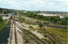
Vale of Glamorgan Cardiff (General) & Barry Pier | View of Barry junction and station, showing Vale of Glamorgan down loop and banking engine spur and catch points. The EWS wagon repair centre at the former Barry MPD is on the right. The double line curve runs to Barry Island | Harbour Rd overbridge, Barry junction | 0 | 07 | SW | ||
 bpm02848.jpg |
VOG BRY |
Vale of Glamorgan Cardiff (General) & Barry Pier | View of Barry junction and station, showing Vale of Glamorgan down loop and banking engine spur and catch points. The sidings on the right previously linked No.1 Dock but the link was severed after 1964, one long siding being used as a backshunt for MGR trains and the others, for the Civil engineer's use but the connection was severed in May 2007. The double line curve runs to Barry Island | Harbour Rd overbridge, Barry junction | 0 | 07 | SW | ||
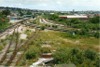
 bpm02849.jpg |
VOG | Vale of Glamorgan | Up and down Vale of Glamorgan lines with down loop on the left. St.Nicholas wide-arch road overbridge spans the former 4-line formation. An advanced starting banner repeater signal is seen between the down main and loop lines and gives an upper quadrant display | Harbour Rd overbridge, Barry junction | 0 | 07 | NE | ||
 bpm02850.jpg |
BRY | Cardiff (General) & Barry Pier | Looking south towards Barry station from the new Gladstone Rd overbridge, showing the up & down main Barry Branch and new flats under construction. The high level sidings stood to the left of the lines | Gladstone Road overbridge leading to the Waterfront, Barry, No.1 dock | 7 | 45 | NE | ||
|
Photos 2801-2850 |
|||||||||
|
Date Last Revised:December 15, 2009 |
|||||||||