|
Historical Railway Photograph Gallery 2901-2950 |
|||||||||
|
Photos 2901-2950 |
|||||||||
| Photo | ELR | Branch | Subject | Location | M | C | Elev'n | Date | Time |
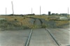
 bpm02901.jpg |
KID SWM |
Kidwelly South Wales Main |
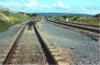
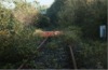
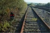
Looking east from the headshunt for the run-around facility for Cwmmawr (Coedbach Washery) traffic at Kidwelly. Evidence of how far the loco ran is seen at the change from shine to rusty rail surface | East of Kidwelly signal box, station and level crossing |
1 234 |
70.5 21.5 |
NW | 19-Jun-90 | 18.33 |
 bpm02902.jpg |
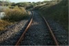
SWM | South Wales Main | 1:15 Facing crossover 420A & B, from down to up main South Wales Main line. The crossover principally served coal traffic access to the Kidwelly branch for the Coedbach Washery facility which finally closed in 1996 | Kidwelly junction immediately east of Morfa Main crossing | 233 | 75.5 | NW | 19-Jun-90 | 18.43� |
 bpm02903.jpg |
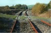
SWM | South Wales Main | A view of the facing crossover from the down to up South Wales Main line and then the lead to the siding & run-around lines for the Kidwelly branch | Kidwelly junction immediately east of Morfa Main crossing | 233 | 72.75 | SE | 19-Jun-90 | 18.49 |
 bpm02904.jpg |
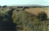
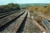
SWM | South Wales Main | Looking towards Pembrey and Burry Port from bridleway overbridge east of Kidwelly junction. Note the monuments on the lineside, these being fixed reference points for checking the alignment of the curve | Bridleway overbridge east of Kidwelly junction | 233 | 72.75 | NW | 19-Jun-90 | 18.52 |
 bpm02905.jpg |
CMM | Burry Port & Gwendraeth Valley | Out-of-use spur line leading to the former Burry Port dock | Burry Port, east of zero mileage datum | - | - | North | 22-Jun-90 | 18.41 |
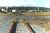 bpm02906.jpg |
CMM | Burry Port & Gwendraeth Valley | Out-of-use spur line leading to the former Burry Port dock from Burry Port sidings, showing level crossing and severed second line | Burry Port, east of zero mileage datum | - | - | South | 22-Jun-90 | 18.42 |
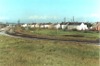 bpm02907.jpg |
CMM | Burry Port & Gwendraeth Valley | General view of the remaining sidings at Burry Port with a spur leading to Burry Port dock. All lifted later | South-east of Burry Port & Pembrey station, east of zero datum | - | - | West | 22-Jun-90 | 18.43 |
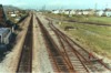 bpm02908.jpg |
SWM | South Wales Main | South Wales Main up & down lines with connection to the remaining sidings at Burry port, the nearest right hand siding, seen curtailed, was for the area civil engineer's use. By year 2006, none of these sidings existed. The wind turbine, just perceptable with the pylons above the second semi-detached house on the right, had also been removed | Road overbridge Immediately east of Burry Port & Pembrey station | 229 | 12 | West | 22-Jun-90 | 18.43� |
 bpm02909.jpg |
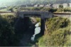
CMM SWM |
Burry Port & Gwendraeth Valley South Wales Main |
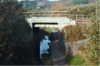
Reinforced concrete rail overbridge carrying the South Wales Main lines over the lifted Burry Port & Gwendraeth Valley single line. This area was subject to regular flooding and was taken out of use as far as Kidwelly junction where later, the line from Kidwelly was the only connection to the valley | Gorse Bridge No.2. Intersection of South Wales Main line with Burry Port & Gwendraeth Valley line (Photo' point = B4311 Rd overbridge [Bridge No.1] at 0m-29.75c) |
0 229 |
31.5 46 |
SE | 22-Jun-90 | 18.51 |
 bpm02910.jpg |
CMM | Burry Port & Gwendraeth Valley | View of trackbed seen from a footbridge over the single line just north-west of the South Wales Main line intersection with the CMM | Footbridge over former Burry Port & Gwendraeth Valley line at Burry Port | 0 | 34.25 | SE | 22-Jun-90 | 18.53� |
 bpm02911.jpg |
CMM SWM |
Burry Port & Gwendraeth Valley South Wales Main |
View of trackbed seen from a footbridge over the single line just north-west of the South Wales Main line intersection with the CMM | Footbridge over former Burry Port & Gwendraeth Valley line at Burry Port | 0 | 34.25 | NW | 22-Jun-90 | 18.54 |
 bpm02912.jpg |
CMM | Burry Port & Gwendraeth Valley | Trackbed looking towards Pembrey from Furnace Road overbridge | Furnace Rd overbridge (Bridge No.3), between Burry Port & Pembrey | 0 | 51.25 | East | 12-Jul-01 | 14.55 |
 bpm02913.jpg |
CMM | Burry Port & Gwendraeth Valley | Trackbed looking towards Burry Port from Furnace Road overbridge | Furnace Rd overbridge (Bridge No.3), between Burry Port & Pembrey | 0 | 51.25 | West | 12-Jul-01 | 14.55 |
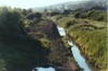
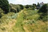
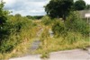
 bpm02914.jpg |
CMM | Burry Port & Gwendraeth Valley | Looking east from B4311 road overbridge, Pembrey, showing the then, recently scarified trackbed and the water channel. The former platform ran along the curve on the left | B4311 overbridge (No.5), between Burry Port & Pembrey | 1 | 18.25 | West | 22-Jun-90 | 19.03 |
 bpm02915.jpg |
CMM | Burry Port & Gwendraeth Valley | Looking north-west towards Kidwelly from Danlan Rd overbridge (Railway name, Jolly Rd) showing high level of water-loving vegetation presence on a very wet trackbed | Danlan Rd (A484) overbridge (No.6), Pembrey (Lando) | 1 | 50 | SE | 22-Jun-90 | 19.06 |
 bpm02916.jpg |
CMM | Burry Port & Gwendraeth Valley | Looking south-east towards Burry Port from Danlan Rd overbridge (Railway name, Jolly Rd) showing high level of water-loving vegetation presence on a very wet trackbed | Danlan Rd (A484) overbridge (No.6), Pembrey (Lando) | 1 | 50 | NW | 22-Jun-90 | 19.06 |
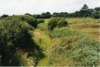
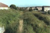
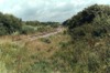
 bpm02917.jpg |
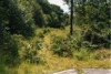
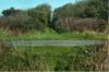
CMM | Burry Port & Gwendraeth Valley | Looking north across the moor towards Pinged and Kidwelly Branch junction from No.8 road overbridge (B4317), showing high level of water-loving vegetation. Former Craiglon halt platform was on the left of the cutting | Former Craiglon halt (B4317) road overbridge (No.8) | 2 | 09 | South | 22-Jun-90 | 19.07 |
 bpm02918.jpg |
CMM | Burry Port & Gwendraeth Valley | Looking south-west at Parc-y-Llong level crossing. Spwdwr Rd overbridge is just visible in the distance. In 2006, reeds over 6ft in height, dominated both sides of the level crossing | Parc-y-Llong level crossing between Kidwelly and Pontyates | 5 | 28 | NE | 22-Jun-90 | 19.20 |
 bpm02919.jpg |
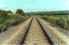
KID | Kidwelly | An excellent section of permanent way in the south-west approach to Coedbach Washery complex. The rail section is BS113A with Pandrol fasteners on concrete sleepers | South of Coedbach Washery | 1 | 30 | NW | 22-Jun-90 | 19.30 |
 bpm02920.jpg |
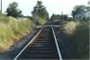
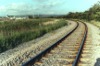
KID | Kidwelly | A well-defined curve just south-west of Coedbach Washery complex | Southern approach to Coedbach Washery | 1 | 05 | NW | 22-Jun-90 | 19.35 |
 bpm02921.jpg |
KID | Kidwelly | Looking north-east towards the connection from the Kidwelly branch to the Coedbach Washery reception & holding sidings | Inlet to reception sidings at Coedbach Washery | 0 | 75 | West | 22-Jun-90 | 19.37 |
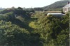
 bpm02922.jpg |
KID | Kidwelly | Coedbach Washery complex looking from the west | South-west of Coedbach Washery, north-east of Kidwelly | 0 | 73.5 | West | 22-Jun-90 | 19.37� |
 bpm02923.jpg |
KID | Kidwelly | Part of the coedbach Washery complex viewed from the Kidwelly branch just west of the 0M-60C milepost | Coedbach Washery | 0 | 61 | West | 22-Jun-90 | 19.39 |
 bpm02924.jpg |
KID | Kidwelly | Coedbach Washery complex looking from the west, with the line to Kidwelly Branch junction and Cwmmawr running straight ahead | Coedbach Washery | 0 | 55 | West | 22-Jun-90 | 19.41 |
 bpm02925.jpg |
KID | Kidwelly | Coedbach Washery complex viewed from an agricultural level crossing within the confines of the site | Coedbach Washery | 0 | 52 | West | 22-Jun-90 | 19.42 |
 bpm02926.jpg |
KID | Kidwelly | Looking north-east at Coedbach Washery reception/dispatch sidings, with modern coal container wagons present. | Coedbach Washery sidings | 0 | 64 | West | 22-Jun-90 | 19.44 |
 bpm02927.jpg |
CMM | Burry Port & Gwendraeth Valley | Looking west where the line from Burry Port ran into Kidwelly Branch junction. The partly-visible yellow board on the left read: 0M-14.6C BPGV = 4M-59.5C CMM | Kidwelly Branch junction | 4 | 61.5 | NE | 23-Jun-90 | 13.34 |
 bpm02928.jpg |
KID CMM |
Kidwelly Burry Port & Gwendraeth Valley |
Looking west from where the line from Burry Port ran into Kidwelly Branch junction | Kidwelly Branch junction |
0 4 |
14.6 59.5 |
NE | 23-Jun-90 | 13.47 |
 bpm02929.jpg |
CMM | Burry Port & Gwendraeth Valley | The area east of the point where the original Burry Port & Gwendraeth valley line (CMM) joined the Kidwelly branch. Trimsaran Rd halt was located beyond the Spwdwr road overbridge in the distance | Kidwelly Branch junction | 4 | 55.1 | SW | 23-Jun-90 | 13.48 |
 bpm02930.jpg |
KID CMM |
Kidwelly Burry Port & Gwendraeth Valley |
Looking along the single line of the Kidwelly branch at a point where the lifted BP&GV single line came in from the left. | Just west of Kidwelly Branch junction | 0 | 22 | NE | 23-Jun-90 | 13.50 |
 bpm02931.jpg |
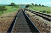
CMM | Burry Port & Gwendraeth Valley | On-track view of Spwdwr road overbridge showing a very wet trackbed. The former Kidwelly Branch junction was located to the rear of the camera point and the former Trimsaran Road halt was located just beyond the bridge | Just west of B4308 Spwdwr road overbridge, east of Kidwelly and west of Trimsaran | 4 | 73 | West | 23-Jun-90 | 14.00 |
 bpm02932.jpg |
CMM | Burry Port & Gwendraeth Valley | Looking towards Cwmmawr and the former British coal opencast disposal site after abandonment. (Compare frames 02873/4 & 5) | Tirclau level crossing (2-track) approx �mile south-west of former Cwmmawr terminus | 12 | 27 | SW | 12-Jul-01 | 14.22 |
 bpm02933.jpg |
CMM | Burry Port & Gwendraeth Valley | Looking downline towards Pontyberem from Tirclau level crossing. The through single line is just visible but the headshunt spur to the left is hidden by vegetation. (Compare frames 02873/4 & 5) | Tirclau level crossing (2-track) approx �-mile south-west of former Cwmmawr terminus | 12 | 27 | NE | 12-Jul-01 | 14.22 |
 bpm02934.jpg |
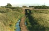
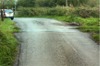
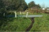
CMM | Burry Port & Gwendraeth Valley | Rails still laid in the road at a level crossing south of Pinged. The level crossing name was not listed in the Swansea sectional Appendix | Tŷ Mawr level crossing, 38 chains north of Craiglon Bridge, Lando | 2 | 47 | West | 13-Oct-06 | 13.30 |
 bpm02935.jpg |
CMM SWM |
Burry Port & Gwendraeth Valley South Wales Main |
View from No.1 Gorse bridge carrying the B4311 road, showing later public footpath and water course on the trackbed of the former BP&GV single line at No.2 Gorse Bridge, carrying the South Wales Main line, Burry Port | Intersection of South Wales Main with former BP & GV line, Burry Port |
0 229 |
31.5 46 |
SE | 03-Nov-06 | 12.10 |
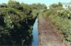
 bpm02936.jpg |
CMM | Burry Port & Gwendraeth Valley | No.1 Gorse bridge carrying the B4311 road, showing later public footpath and water course on the trackbed of the former BP&GV single line. No.2 Gorse Bridge carrying the South Wales main line is visible beyond | No.1 Gorse Bridge carrying the B4311 road, Burry Port | 0 | 28 | SE | 03-Nov-06 | 12.12 |
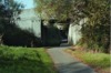
 bpm02937.jpg |
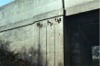
CMM | Burry Port & Gwendraeth Valley | No.1 Gorse bridge carrying the B4311 road, showing 5 railway telegraph insulators still in position where the aerial wires were terminated and cabled under the bridge to again become aerial on the other side of the Gorse bridges. | No.1 Gorse Bridge carrying the B4311 road, Burry Port | 0 | 28.75 | SE | 03-Nov-06 | 12.13 |
 bpm02938.jpg |
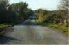
CMM | Burry Port & Gwendraeth Valley | The lane from a junction with the A484 road west of Lando, showing the humped area at the former Tŷ Mawr level crossing where the rails are still in position in the roadway | Tŷ Mawr level crossing in lane from the A484 to Pinged north of Craiglon Bridge and Lando | 2 | 47 | East | 03-Nov-06 | 12.35 |
 bpm02939.jpg |
CMM | Burry Port & Gwendraeth Valley | The lane from a junction with the A484 road west of Lando, showing the humped area at the former Tŷ Mawr level crossing where the rails are still in position in the roadway (Just visible between the concrete posts) | Tŷ Mawr level crossing in lane from the A484 to Pinged, north of Craiglon Bridge and Lando | 2 | 47 | South | 03-Nov-06 | 12.35 |
 bpm02940.jpg |
CMM | Burry Port & Gwendraeth Valley | The site of Pinged level crossing in an unclassified lane north of the A484 Pembrey-Kidwelly road. The rails are still embedded in the tarmac. The view is looking north-east towards the former Trimsaran jct and towards Kidwelly Branch jct. Earlier there was a halt 2 chains south of this crossing, serving the Pinged hamlet. | Former Pinged level crossing | 3 | 24 | NE | 03-Nov-06 | 12.41 |
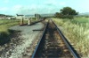
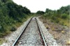
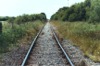
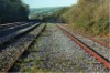
 bpm02941.jpg |
KID | Kidwelly | The well-overgrown curtailed single line and timber buffer stop with "STOP" sign just west of the old A484 road overbridge, south end of Kidwelly | Just west of the former A484 road overbridge, south of Kidwelly | 1 | 45 | West | 03-Nov-06 | 12.53� |
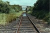
 bpm02942.jpg |
KID | Kidwelly | Looking east towards the timber buffer stop at the cutting just west of the former A484 road overbridge, south of Kidwelly. | Just south of Morfa Main level crossing, Kidwelly | 1 | 55 | West | 03-Nov-06 | 12.54 |
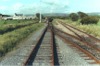
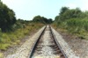
 bpm02943.jpg |
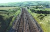
KID | Kidwelly | Looking west at the out-of-use single line Kidwelly branch. The South Wales Main lines are on the left | Morfa Main level crossing, Kidwelly | 1 | 55 | South | 03-Nov-06 | 12.56 |
 bpm02944.jpg |
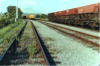
KID SWM |
Kidwelly South Wales Main |
The rarely used reception siding at Kidwelly used extensively for traffic to & from Coedbach Washery before closure of that establishment in 1996 and now used only occasionally for berthing track maintenance stock. | Morfa Main level crossing, Kidwelly | 233 | 78 | South | 03-Nov-06 | 12.56 |
 bpm02945.jpg |
KID SWM |
Kidwelly South Wales Main |
The crossover from the former reception siding for the Kidwelly and BP&GV branch to the single line branch itself. The right-hand siding was used for running around the trains | North of Morfa Main level crossing, Kidwelly |
1 234 |
56 00 |
South | 03-Nov-06 | 12.57� |
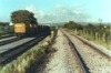
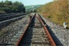 bpm02946.jpg |
KID SWM |
Kidwelly South Wales Main |
422 points, part of a 1 in 9� 113A flat-bottom turnout manufactured in 1982. Through this crossover, coal traffic to and from Coedbach Washery and the Kidwelly & Cwmmawr branches passed, the right-hand siding being the run-around facility for the locomotive. The branch was abandoned after the cessation of traffic post-1996. Lifting of the line was postponed after ecological considerations came into effect. The headshunt buffer stop is not visible but is very close to Kidwelly signal box | 321 signal and 422 points at start of Kidwelly branch |
1 234 |
45.5 0.5 |
South | 03-Nov-06 | 13.08 |
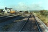
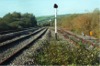
 bpm02947.jpg |
KID SWM |
Kidwelly South Wales Main |
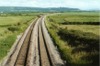
Looking north along the run-around loop (right) and the reception siding (centre) with the up & down South Wales Main lines on the left. | Just north of signals K118 and 322, Kidwelly reception siding and run-around. |
1 234 |
60.5 04.5 |
South | 03-Nov-06 | 13.08� |
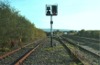 bpm02948.jpg |
KID SWM |
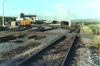
Kidwelly South Wales Main |
Looking south at signal K118, towards Morfa Main level crossing, Kidwelly. In accordance with current practice at the time, the former tungsten bulb lighting in the ground signal, (322) has been replaced by LED lighting. The previous horizontally-spaced white and red lights indicating STOP are now showing two reds. The proceed indication is as before, viz: two whites at 45 degrees | Signal K118 and 322 at run-around and reception sidings, Kidwelly. |
1 234 |
60.5 04.5 |
North | 03-Nov-06 | 13.12 |
 bpm02949.jpg |
KID SWM |
Kidwelly South Wales Main |
A close-up of a new LED-illuminated ground signal (322) at Kidwelly run-around loop on the out-of use Kidwelly branch to Cwmmawr | Signal K118 and 322 at run-around and reception sidings, Kidwelly. |
1 234 |
60 0.4 |
North | 03-Nov-06 | 13.13� |
| bpm02950.jpg | SPARE | ||||||||
|
Photos 2901-2950 |
|||||||||
|
Date Last Revised:December 16, 2009 |
|||||||||