|
Historical Railway Photograph Gallery 301-350 |
|||||||||
| 251-300 <- |
Photos 301-350 |
-> 351-400 | |||||||
| Photo | ELR | Branch | Subject | Location | M | C | Elev'n | Date | Time |
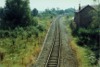
 bpm00301.jpg |
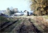
CFS | Coleford | Coleford Severn & Wye station. A car park & shopping parade now exist here | Coleford, Gloucester | 16 | 43 | East | 22-Oct-67 | 15.08 |
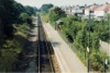
 bpm00302.jpg |
CFS | Coleford | Coleford Severn & Wye station. A car park & shopping parade now occupy this site | Coleford, Gloucester | 16 | 43 | West | 22-Oct-67 | 15.09 |
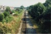
 bpm00303.jpg |
CFS | Coleford | Coleford Severn & Wye station site, now replaced by a shopping precinct | Coleford, Gloucester | 16 | 35 | East | 22-Oct-67 | 15.10 |
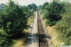
 bpm00304.jpg |
CFS | Coleford | Looking east from former Coleford station area. An industrial estate now stands here but the trackbed has survived as a walkway/cycleway | Coleford, Gloucester | 16 | 30 | West | 22-Oct-67 | 15.14 |
 bpm00305.jpg |
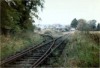
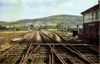
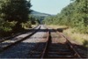
CFS | Coleford | Severn & Wye to Coleford & Monmouth branch junction. The nearest points were worked from a groundframe and the through route to the left to connect with Whitecliffe quarry, was not possible without a reversal prior to 1951. A central town bypass road now crosses the scene just beyond the camera point | Coleford, east of former GW and Severn & Wye stations | 16 | 32 | North | 22-Oct-67 | 15.15 |
 bpm00306.jpg |
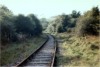
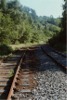
CFS | Coleford | Out-of-use single track to Whitecliffe quarry | South of Newland Street rail overbridge, Coleford | 5 | ? | North | 22-Oct-67 | 15.29 |
 bpm00307.jpg |
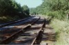
CFS | Coleford | Abandoned single line on Newland Street rail overbridge | Newland Street rail overbridge, Coleford | 5 | ? | West | 22-Oct-67 | 15.29 |
 bpm00308.jpg |
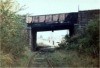
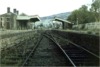
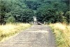
CFS | Coleford | View of Coleford (GWR) station through road overbridge at Coleford, the bridge now having been removed & the cutting backfilled. A roundabout now stands at road level where the bridge stood | Road overbridge, Coleford | 5 | 03 | West | 22-Oct-67 | 15.32 |
 bpm00309.jpg |
CFS | Coleford | Abandoned single line reverse curve looking from west end of Coleford GWR station through road overbridge, since removed, backfilled and converted to a road. A roundabout now stands at road level at this location | Road overbridge, former Coleford GWR station | 5 | 04 | East | 22-Oct-67 | 15.32 |
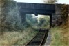
 bpm00310.jpg |
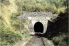
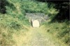
CFS | Coleford | South Western portal of 55-yard Whitecliffe tunnel | Whitecliffe Quarry, Coleford | 4 | 34 | West | 22-Oct-67 | 15.55 |
 bpm00311.jpg |
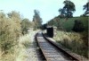
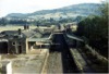
CFS | Coleford | Whitecliffe Quarry sidings | Whitecliffe, Coleford | 4 | 34.5 | East | 22-Oct-67 | 15.56 |
 bpm00312.jpg |
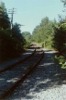
CFS | Coleford | Single-lever groundframe controlling single blade catchpoint east of Whitecliffe tunnel & quarry | Whitecliffe tunnel, Coleford | 4 | 40 | West | 22-Oct-67 | 15.58 |
 bpm00313.jpg |
WYE ROS |
Wye Valley/ Ross-on-Wye & Little Mill junction | Troy junction when line was still in use for casual freight traffic from Chepstow to Monmouth May Hill | Monmouth Troy signal box & junction |
13 13 |
07 66 |
West | ||
 bpm00314.jpg |
ROS WYE |
Wye Valley/ Ross-on-Wye & Little Mill junction | Monmouth Troy station when line was still in use for casual freight traffic from Chepstow to Monmouth May Hill | Monmouth Troy station | 13 | 11.5 | West | ||
 bpm00315.jpg |
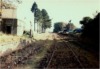
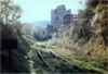
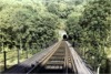
ROS | Ross-on-Wye & Little Mill junction | Monmouth Troy station after complete removal of all permanent way and as viewed from former A40T road above east portal of Monmouth tunnel. A private housing estate now stands centre-to-left of the track bed. Note that although all the signal arms are gone, the telegraph wires are still attached to the insulators on the poles at the time of photographing. The station building later was dismantled and re-erected at Winchcombe on the Gloucester-Warwickshire Railway | Monmouth Troy station | 13 | 11 | SW | 16-Sep-64 | 11.17 |
 bpm00316.jpg |
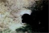
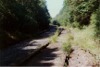
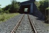
ROS | Ross-on-Wye & Little Mill junction | South portal of 630-yard Lydbrook tunnel (From 4M-63C to 5M-11C) | North of Lydbrook junction station | 5 | 12 | South | 12-Oct-63 | |
 bpm00317.jpg |
ROS | Ross-on-Wye & Little Mill junction | South portal of 630-yard Lydbrook tunnel (From 4M-63C to 5M-11C) after bricking up | North of Lydbrook junction station | 5 | 15 | South | 28-Aug-67 | 14:08 |
 bpm00318.jpg |
ROS | Ross-on-Wye & Little Mill junction | Lydbrook River overbridge after tracklifting | North of Lydbrook junction station | 5 | 22 | South | 28-Aug-67 | 14:03 |
 bpm00319.jpg |
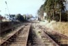
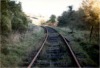
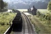
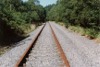
ROS | Ross-on-Wye & Little Mill junction | Station with former down platform line reduced to siding status | Kerne Bridge station | 4 | 7.5 | North | 12-Oct-63 | |
 bpm00320.jpg |
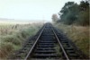
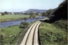
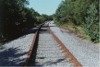
ROS | Ross-on-Wye & Little Mill junction | The then newly relaid & ballasted single line at Goodrich road overbridge | Kerne Bridge station | 4 | 7.5 | South | 12-Oct-63 | |
 bpm00321.jpg |
ROS | Ross-on-Wye & Little Mill junction | Lydbrook River bridge (113 yards). Note that the bullhead guard rails have been removed from the support chairs either side of the running lines | North of Lydbrook junction | 5 | 18 | South | 12-Oct-63 | |
 bpm00322.jpg |
APG | Aberpergwm | Disused 'No.10 railway' lines to former Aberpergwm colliery | Near former Aberpergwm colliery, south of Glyn Neath | 0 | 28.5 | NW | ||
 bpm00323.jpg |
APG | Aberpergwm | Approach to river bridge showing turnout( Heads of Valleys road now passes through this point). The bridge with track survives (2003). | Near former Aberpergwm colliery, south of Glyn Neath | 0 | 29 | East | ||
 bpm00324.jpg |
APG | Aberpergwm | View of disused tracks North-West of Aberpergwm Colliery junction | North-west of Aberpergwm Colliery junction | 0 | 10 | NW | ||
 bpm00325.jpg |
APG | Aberpergwm | View of disused tracks North-West of Aberpergwm Colliery junction | North-west of Aberpergwm Colliery junction | 0 | 06 | SE | ||
 bpm00326.jpg |
APG | Aberpergwm | Disused No.10 railway lines to former Aberpergwm Colliery. View looking towards former junction with Vale of Neath Line | North-west of Aberpergwm Colliery junction | 0 | 08 | NW | ||
 bpm00327.jpg |
APG | Aberpergwm | Disused No.10 railway lines to former Aberpergwm Colliery. View looking towards Aberpergwm colliery site | North-west of Aberpergwm Colliery junction | 0 | 08 | SE | ||
 bpm00328.jpg |
APG | Aberpergwm | Disused No.10 railway lines to former Aberpergwm Colliery (Former private siding gate post location visible) | North-west of Aberpergwm Colliery junction | 0 | 4.5 | East | ||
 bpm00329.jpg |
VON | Neath (General) & Pontypool Road | View at site of Aberpergwm Colliery junction where the Vale of Neath Line formerly carried on to Aberdare etc | Aberpergwm Colliery junction |
33 0 |
14 00 |
SW | ||
 bpm00330.jpg |
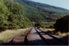
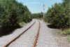
VON | Neath (General) & Pontypool Road | View of mothballed single (up) line approaching former Aberpergwm Colliery junction (Brought back into use in mid 1990s) | South of Cwmgwrach, Glyn Neath | ~33 | 34 | SW | ||
 bpm00331.jpg |
VON | Neath (General) & Pontypool Road | Double track river Neath skew bridge showing single line (mothballed at time but later reinstated) | North of Castle siding, Resolven area | ~34 | 30 | SW | ||
 bpm00332.jpg |
VON | Neath (General) & Pontypool Road | Singled and slewed down-to-up line near Castle siding | Castle siding, Resolven area | SW | ||||
 bpm00333.jpg |
VON | Neath (General) & Pontypool Road | Single down line with turnout at rail overbridge at Castle siding location, North of Resolven | Castle siding, Resolven area | 36 | ? | SW | ||
 bpm00334.jpg |
VON | Neath (General) & Pontypool Road | Single (down) line with turnout & river bridge | Castle siding, Resolven area | 36 | ? | SW | ||
 bpm00335.jpg |
NAB | Neath Riverside & Brecon (Free Street) | North loop junction north of Blaenant colliery | North of former Blaenant colliery | 4 | 30 | North | ||
 bpm00336.jpg |
NAB | Neath Riverside & Brecon (Free Street) | Track detail with down electric stop signal | North of former Blaenant colliery | 4 | 30 | South | ||
 bpm00337.jpg |
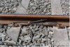
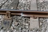
RSB | Rhondda & Swansea Bay | Then newly-installed 113A fb track with track-circuit bonds & showing HDPE insulators under pandrol fixings | Dynevor groundframe | 19 | 36 | East | ||
 bpm00338.jpg |
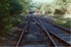
VON | Neath (General) & Pontypool Road | Out-of-use track at Neath & Brecon junction down permanent caution semaphore (Track was reinstated in 1990s to serve Ryan's opencast site at Cwmgwrach) | Down fixed distant signal for N&B junction signal box | SW | ||||
 bpm00339.jpg |
RSB | Rhondda & Swansea Bay | Conversion weld from 95lb/yard bull head to 113A flat bottom rail | Skewen/Llandarcy coal processing plant | 19 | 36 | East | ||
 bpm00340.jpg |
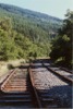
VON | Neath (General) & Pontypool Road | Mothballed (at time of photograph) single line with skew A465 road overbridge. Line brought back into use in 1990's for Ryan coal disposal site at Cwmgwrach, Glyn Neath | Former Neath-Rhigos road overbridge near Aberdulais | North | ||||
 bpm00341.jpg |
CRY | Coryton | Realigned single line from new Heath junction to Coryton line, Heath Low Level junction | Heath junction (Low Level halt road overbridge) | 0 | 25 | NW | ||
 bpm00342.jpg |
CRY | Coryton | Birchgrove station viewed from A469 Caerphilly road overbridge | Birchgrove halt | 1 | 33 | East | ||
 bpm00343.jpg |
CRY | Coryton | Birchgrove station viewed from stone arched bridlebridge west of Birchgrove station | West of Birchgrove halt | 1 | 46 | West | ||
 bpm00344.jpg |
CRY | Coryton | View looking towards Rhiwbina station from stone arched bridle/footbridge west of Birchgrove station | West of Birchgrove halt | 1 | 46 | East | ||
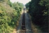
 bpm00345.jpg |
CRY | Coryton | View looking towards Rhiwbina station from road overbridge | East of Rhiwbina halt (Road overbridge) | 1 | 65 | East | ||
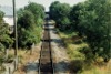
 bpm00346.jpg |
CRY | Coryton | View looking towards Birchgrove station from road overbridge east of Rhiwbina station | East of Rhiwbina halt (Road overbridge) | 1 | 65 | West | ||
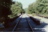
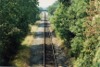
 bpm00347.jpg |
CRY | Coryton | Rhiwbina station viewed from pedestrian footbridge | Rhiwbina halt | 1 | 74.5 | East | ||
 bpm00348.jpg |
CRY | Coryton | View from pedestrian footbridge at Rhiwbina station looking towards road overbridge | Rhiwbina halt | 1 | 74.5 | West | ||
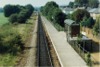
 bpm00349.jpg |
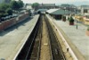
CAR | Cardiff, (Stonefield junction) & Rhymney | View of main area of station from station footbridge | Caerphilly station | 8 | 20 | East | ||
 bpm00350.jpg |
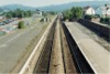
CAR | Cardiff, (Stonefield junction) & Rhymney | View of platforms & facing crossover from station footbridge | Caerphilly station | 8 | 20 | West | ||
| 251-300 <- |
Photos 301-350 |
-> 351-400 | |||||||
|
Date Last Revised:December 10, 2009 |
|||||||||