|
Historical Railway Photograph Gallery 501-550 |
|||||||||
| 451-500 <- |
Photos 501-550 |
-> 551-600 | |||||||
| Photo | ELR | Branch | Subject | Location | M | C | Elev'n | Date | Time |
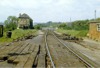
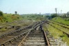
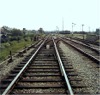
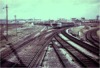
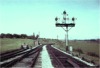
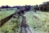
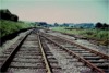
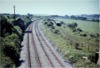
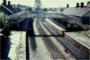
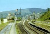 bpm00501.jpg |
WVL | Gaer junction & Aberbeeg junction | Part view of station where left hand lines ran to Nine Mile Point, Wyllie & Tredegar and the turnout in the down main crossed to join the Western Valleys line to Ebbw Vale, Abertillery & Oakdale colliery. Note the checked curves between the platforms. Risca junction signal box in the background, along with the visible permanent way was completely removed in the 1970's. Note that the signals are cleared for the Ebbw Vale line and the Sirhowi valley line as it was a Sunday and the signal box was switched out | Risca station | 5 | 47 | SE | 11-Jun-67 | 11.25 |
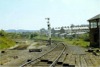
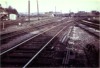
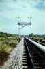
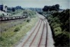
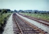
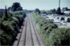
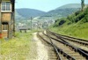 bpm00502.jpg |
WVL | Gaer junction & Aberbeeg junction | View from Risca junction signal box, looking along the Western Valleys line towards Crosskeys. Only one line survives here (2004), and served the BSC (formerly Corus) Ebbw Vale plant which no longer exists. Originally this was a double line scissors junction. The line is due to re-open to passengers in 2007 | Risca junction signal box | 5 | 51 | SE | 11-Jun-67 | 11.30 |
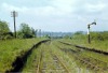
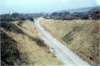
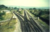
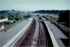
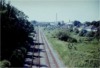
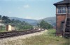 bpm00503.jpg |
NMP | Nine Mile Point & Risca | View of double line to Nine Mile Point, Wyllie & Tredegar (LMS beyond Nine Mile Point). The entire line, including the earthworks of the embankment and the 88-yard Risca viaduct over the river Ebbw in the distance, was removed in the 1970's and part of the trackbed towards Nine Mile point was reworked to form the new Newport-Ebbw Vale A467 dual carriageway. To the left, the bank, formerly known as the 'long bridge' contained 33 arches and was demolished around the turn of the last century and replaced by a part-arched earth embankment which lasted until the second demolition. Originally this was a double line scissors junction | Risca junction signal box | 5 | 51 | SE | 11-Jun-67 | 11.30� |
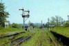
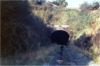
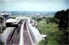
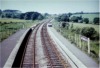
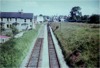
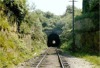 bpm00504.jpg |
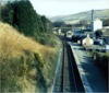
HRD | Halls Road | General view of single line at west portal of 239-yard Penar tunnel. The line was closed completely in 1989 & lifted north of Crosskeys shortly afterwards | Penar tunnel, west side (tunnel bore was from 4M-42C to 4M-53C) | 4 | 55 | West | 11-Jun-67 | 12.00 |
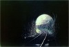
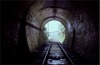 bpm00505.jpg |
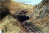
HRD | Halls Road | West portal of 239-yard Penar tunnel, viewed from inside | Penar junction (tunnel ran from 4M-42C to 4M-53C) | 4 | 57 | East | 11-Jun-67 | 11.58 |
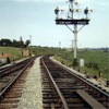
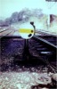
 bpm00506.jpg |
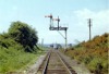
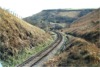
HRD | Halls Road | Single line from Penar Tunnel to Penar junction with 2-doll bracket home semaphore reading to Vale of Neath line & Oakdale branches respectively | East of Penar junction (Halls Road branch) | 4 | 63 | SE | 11-Jun-67 | 12.02 |
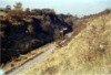
 bpm00507.jpg |
VON | Neath (General) & Pontypool Road | Abandoned double line looking towards Pentwynmawr Platform. Part of this line was re-used for a run-around facility when the Halls Road branch was mothballed in 1964, the Tredegar branch temporarily being used to access Oakdale colliery via the VON line from Tredegar Lower junction. When Wyllie colliery & the Tredegar line closed, the Halls Road branch was reinstated & remained in use until closure in 1989 | East of Penar junction [Vale of Neath (Taff Vale Extension) line] | 7 | 55 | SW | 11-Jun-67 | 12.05 |
 bpm00508.jpg |
VON | Neath (General) & Pontypool Road | View of Vale of Neath up & down main lines with part lifted sidings & 2-doll bracket signal assembly | East of Penar junction Vale of Neath (Taff Vale Extension) line | 7 | 55 | NE | 11-Jun-67 | 12.05 |
 bpm00509.jpg |
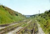
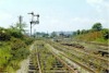
PEN | Penar Jct & Oakdale colliery | Sleeper crossing with compound points & vehicular level crossing beyond & also former stationmaster's/crossing keeper's house on Oakdale branch just west of Penar junction. This was the single-to-double line junction | Penar junction | 4 | 71 | SE | 11-Jun-67 | 12.10 |
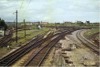
 bpm00510.jpg |
PEN | Penar Jct & Oakdale colliery | Layout at Penar junction after rationalisation & closure of Vale of Neath line | Penar junction signal box |
7 4 |
64 71 |
West | 11-Jun-67 | 12.10 |
 bpm00511.jpg |
VON | Neath (General) & Pontypool Road | Abandoned double line at former Penar junction Halt. (This track was temporarily brought back into use after 1964 & the access to Oakdale colliery from the Halls Road Branch was mothballed for a time while the Vale of Neath line was re-instated between Bird-in Hand East & Penar junction in order to use the former LMS Sirhowi line to Nine Mile Point & Newport) | Former Penar junction Halt | 7 | 66 | NE | 11-Jun-67 | 12.14 |
 bpm00512.jpg |
VON | Neath (General) & Pontypool Road | Abandoned Double line at former Penar junction Halt. (This track was temporarily brought back into use after 1964 & the access to Oakdale colliery from the Halls Road Branch, was mothballed for a time while the Vale of Neath line was re-instated between Bird-in-Hand East & Penar junction) | Former Penar junction Halt | 7 | 66 | SW | 11-Jun-67 | 12.15 |
 bpm00513.jpg |
VON | Neath (General) & Pontypool Road | Compound crossings in former Vale of Neath lines to Oakdale/Halls Road sections (Note that only the passenger line portion of the crossings has a facing point lock (under the hinged protection cover) | Penar junction |
7 4 |
60 67 |
SW | 11-Jun-67 | 12.18 |
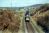 bpm00514.jpg |
AYT | Carmarthen & Aberystwyth | Diesel-hauled milk train approaching Maesycrugiau from Llanybyther. It is not known whether this train worked from Aberayron or Pont Llanio. Note the density of the aerial telegraph rig. (This route was formerly the GW main line to Aberystwyth) | West of Llanllwni (Road overbridge to Maesycrugiau) | 3 | 50.75 | SW | 1967 | |
 bpm00515.jpg |
AYT | Carmarthen & Aberystwyth | Superelevated single line immediately south of Pont Llanio station & Milk Marketing Board creamery. (Line was out-of-use north of Pont Llanio at time of photograph) | Road overbridge south of Pont Llanio station | 19 | 45.75 | NW | ||
 bpm00516.jpg |
BRY | Cardiff (General) & Barry Pier | Cadoxton North Yard track arrangement after partial lifting of Wenvoe lines & crossings in up & down main Barry-Cardiff lines | Cadoxton South junction |
6 0 |
6 00 |
South | ||
 bpm00517.jpg |
CTD | Cadoxton South junction & Treforest junction | Junction to west side of north yard at Cadoxton North sidings, showing facing point fouling bar when in full use | 3-track Rail overbridge north of Palmerston | ~0 | 42 | North | ||
 bpm00518.jpg |
CTD | Cadoxton South junction & Treforest junction | Reciprocal view of bpm00517.jpg | 3-track Rail overbridge north of Palmerston | ~0 | 42 | South | ||
 bpm00519.jpg |
CTD | Cadoxton South junction & Treforest junction | Cross-view of trackbed & down distant signal for Wenvoe after tracklifting | South of Wenvoe tunnel | ~3 | 15 | East | ||
 bpm00520.jpg |
CTD | Cadoxton South junction & Treforest junction | South portal of Wenvoe tunnel after tracklifting | Wenvoe tunnel, south portal | 3 | 21 | SE | ||
 bpm00521.jpg |
AYT | Carmarthen & Aberystwyth | Pont Llanio station platform with signal box, passing loop & part of Milk Marketing Board's creamery & sidings all now defunct | Road overbridge immediately south of Pont Llanio station | 19 | 45� | South | ||
 bpm00522.jpg |
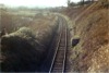
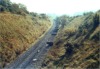
CAN | Carmarthen & Newcastle Emlyn | Deep cutting approach Pencader tunnel, Llanpumpsaint-side. Wooden aqueduct passing over top of portal is just visible | South-west side of Pencader tunnel | 257 | 55 | SW | ||
 bpm00523.jpg |
CAN | Carmarthen & Newcastle Emlyn | View of single line curve approaching south-west portal of Pencader tunnel with aqueduct passing across left of top blockwork | South side of Pencader tunnel | 257 | 55 | NW | 1967 | |
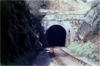 bpm00524.jpg |
CAN | Carmarthen & Newcastle Emlyn | View of south-west portal of 988-yard Pencader tunnel with aqueduct passing across left of top blockwork. Tunnel ran from 257M-58C to 258M-23C | South portal of Pencader tunnel | 257 | 57 | SW | ||
 bpm00525.jpg |
|||||||||
 bpm00526.jpg |
CAN | Carmarthen & Newcastle Emlyn | View through south portal of Pencader tunnel from tunnel interior | Pencader tunnel, south side | 257 | 59 | North | ||
 bpm00527.jpg |
CTD | Cadoxton South junction & Trehafod junction | Trackbed of Wenvoe branch after recovery of line by contractor | Just north of Argae Lane underbridge, Cadoxton North | South | ||||
 bpm00528.jpg |
CTD | Cadoxton South junction & Trehafod junction | Trackbed of Wenvoe branch after recovery of line by contractor (Not a good photo�) | Vishwell Road overbridge between Cadoxton & Wenvoe | 1 | 78.5 | North | ||
 bpm00529.jpg |
BRY | Cardiff (General) & Barry Pier | View of part of Cadoxton South junction after partial truncation of permanent way as seen from signal box | Cadoxton South signal box | 6 | 06 | South | ||
 bpm00530.jpg |
BRY | Cardiff (General) & Barry Pier | Truncated junction of trailing points from Wenvoe branch as viewed from track level | Cadoxton South signal box & junction | 6 | 5.5 | South | ||
 bpm00531.jpg |
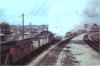
BRY | Cardiff (General) & Barry Pier | 0-6-2 Collett tank loco' on empty Leys coal train, passing Cadoxton South signal box | Cadoxton South signal box & junction | 6 | 06 | South | ||
 bpm00532.jpg |
CTD | Cadoxton South junction & Trehafod junction | Trackbed after recovery of track, viewed from Vishwell Rd road overbridge | Road overbridge between St.Andrews & Wenvoe | 1 | 78.5 | South | ||
 bpm00533.jpg |
CTD | Cadoxton South junction & Trehafod junction | As bpm005323 but reciprocal view looking towards Wenvoe with still-standing down homes bracket signal assembly | Just north of Argae Lane underbridge at Cadoxton North Yard junction | 0 | 43 | South | ||
 bpm00534.jpg |
MHD | Taunton & Minehead | 2-doll bracket signal with permanent caution semaphores for either-line working of lines between Minehead & Dunster. Placed at 1870 yards from Dunster signal box at the time of taking. On removal, the assembly was moved to the Exeter-Barnstable line | Adjacent to former Butlin's Camp (now Westworld), Minehead | 187 | 29 | West | 1979 | |
 bpm00535.jpg |
CAR | Cardiff (Stonefield junction) & Rhymney | View of Heath junction from Highbridge Road overbridge, Heath, west of Roath park, Cardiff | Highbridge Road road overbridge | 3 | 16.75 | South | ||
 bpm00536.jpg |
PTH | Penarth | Sully station after abandonment of line beyond Penarth Cement Works from Penarth end of branch | Road overbridge at south-east end of station | 4 | 57.25 | SE | ||
 bpm00537.jpg |
CRY | Coryton | End of run-around loop & line which formerly ran on to Tongwynlais & Nantgarw. A two-lever groundframe is visible alongside the points | Old A470 road overbridge at Coryton Halt (Single line junction is at 2M-61C) | 2 | 59 | East | ||
 bpm00538.jpg |
Spare | ||||||||
 bpm00539.jpg |
|||||||||
 bpm00540.jpg |
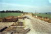
PTH | Penarth | Up & down lines showing partial fragmentation after singling of line for freight only, to Penarth Cement Works. View shows half-compound in up main and track slewed over to connect with down main | Lane overbridge immediately north of Penarth Cement Works signal box | 2 | 33.5 | South | 09-Jun-68 | 11.12 |
 bpm00541.jpg |
PTH | Penarth | Partially truncated lines with diamond crossing in severed up line after closure of Penarth branch to passenger traffic | Connection to former Penarth Cement Works, east of Lavernock | North | ||||
 bpm00542.jpg |
PTH | Penarth | Partially truncated lines with diamond crossing in severed up line after closure of Penarth branch to passenger traffic. Part of the up line visible, shows a fairly recently renewed section of 109lb/yd flat bottomed rail with elastic spike fixings on baseplates | Between Lavernock station and Penarth Cement Works | SW | ||||
 bpm00543.jpg |
PTH | Penarth | Up and down lines between Lavernock station and Penarth Cement Works showing down line in bullhead rail and up line in 109lb/yd flat bottomed rail with elastic spike fixings | Between Lavernock station and Penarth Cement Works | NE | ||||
 bpm00544.jpg |
PTH | Penarth | View of north-east end of Lavernock station after closure of line to passengers. Station road (later Fort Road) rail overbridge is just beyond the station limits | Lavernock station footbridge | 2 | 77 | SW | 09-Jun-68 | |
 bpm00545.jpg |
PTH | Penarth | View of south-west end of Lavernock station after closure of line to passengers | Lavernock station footbridge | 2 | 77 | NE | 09-Jun-68 | |
 bpm00546.jpg |
PTH | Penarth | View of Penarth Cement Works signal box and southern rail connection to works sidings | Bridleway overbridge near Penarth Cement Works signal box | 2 | 33.5 | North | 1968 | |
 bpm00547.jpg |
PTH | Penarth | Looking south from Brockhill Rise road overbridge towards Penarth Cement Works | Brockhill Rise overbridge, lower Penarth | North | 09-Jun-68 | 14.45 | ||
 bpm00548.jpg |
PTH | Penarth | View of double track looking towards Lavernock when up main had been taken out-of-use | Forrest Road overbridge, east of former Lower Penarth halt | 2 | 09 | North | 09-Jun-68 | |
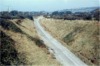
 bpm00549.jpg |
PTH | Penarth | View of double track incline south of Penarth station showing truncated up line when down line was still in use for traffic to Penarth Cement Works | Archer Rd road overbridge south of Penarth station | 1 | 31 | South | 1968 | |
 bpm00550.jpg |
PTH | Penarth | Penarth station after lifting of down platform line (Mileages changed after singling of branch. Old station mileage was 1M-03C, new is 1M-13C?) | Stanwell Rd road overbridge north of Penarth station | 1 | 04 | North | ||
| 451-500 <- |
Photos 501-550 |
-> 551-600 | |||||||
|
Date Last Revised:December 01, 2009 |
|||||||||