|
Historical Railway Photograph Gallery 751-800 |
|||||||||
| 701-750 <- |
Photos 751-800 |
-> 801-850 | |||||||
| Photo | ELR | Branch | Subject | Location | M | C | Elev'n | Date | Time |
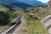
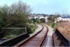
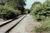
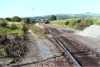
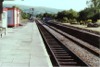
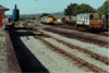
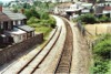
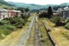
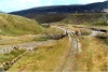
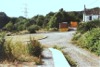
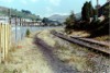
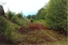
 bpm00751.jpg |
GAW | Tondu & Margam junction & Blaengarw | Single line at Pontyrhyl showing rail overbridge over the Afon Garw. The left foreground was the approximate site of the former passenger station serving Pontyrhyl. The station had staggered platforms. | Pontyrhyl | 3 | 20 | SW | 07-May-89 | 15.30 |
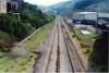
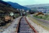
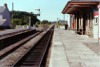
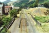
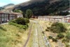
 bpm00752.jpg |
GAW | Tondu & Margam junction & Blaengarw | View of recently reballasted single line track showing reverse curves on approach to Pontycymmer | Pontycymmer | 4 | 00 | South | 07-May-89 | 15.35 |
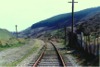
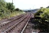
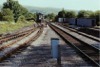
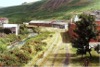
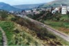 bpm00753.jpg |
GAW | Tondu & Margam junction & Blaengarw | View of line approaching site of former Pontycymmer station which like Pontyrhyl, had staggered platforms. The road overbridge has now been removed and the cutting backfilled | Pontycymmer | 4 | 27 | South | 07-May-89 | 15.38 |
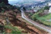
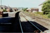
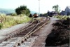
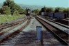
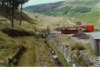
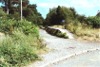
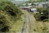
 bpm00754.jpg |
GAW | Tondu & Margam junction & Blaengarw | Looking south along the double track at the site of the former Pontycwmmer station. The track was later curtailed near the large building on the right and by 2006 was barely perceptible. A tennis court intervenes | Road overbridge immediately north of former Pontycymmer station | 4 | 55 | North | 07-May-89 | 15.42 |
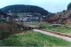
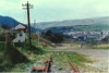
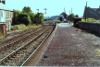
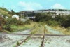
 bpm00755.jpg |
GAW | Tondu & Margam junction & Blaengarw | Looking north-west from the now removed road overbridge at Pontycwmmer. A loading wharf was later constructed near the reverse curve to allow reclaim of "duff" coal from the mountain tips which was taken away by rail over a 5-year period until about 1995. The land has been completely remodelled since this photo-record. | Former Ffaldau colliery siding & inlet, Pontycymmer | 4 | 55 | SE | 07-May-89 | 15.42 |
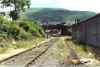
 bpm00756.jpg |
GAW | Tondu & Margam junction & Blaengarw | The end of the line after cessation of colliery traffic and removal of the Blaengarw collieries. The "Whistle" board applies to the level crossing just beyond | Approach to British Rail/British Coal boundary, Blaengarw | 5 | 11 | South | 07-May-89 | 15.50 |
 bpm00757.jpg |
GAW | Tondu & Margam junction & Blaengarw | Looking down the valley towards Pontycwmmer from a level crossing at the former boundary between the NCB and BR after cessation of traffic on the Garw branch | British Rail/British Coal boundary at end of Garw branch | 5 | 14 | North | 07-May-89 | 15.50 |
 bpm00758.jpg |
GAW | Tondu & Margam junction & Blaengarw | Looking across the former level crossing towards the site of the former Blaengarw colliery | British Rail/British Coal boundary at end of Garw branch | 5 | 16 | South | 07-May-89 | 15.54 |
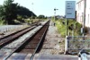
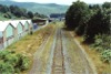
 bpm00759.jpg |
GAW | Tondu & Margam junction & Blaengarw | Looking north-east along single line towards the level crossing Stop board (which has been slewed around by trespassers). The line was still present in 2006 but heavily overgrown | River Garw rail overbridge adjacent to Brynmenyn level crossing | 0 | 08 | SW | 07-May-89 | 16.04 |
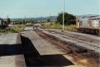
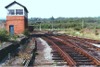 bpm00760.jpg |
BAL POR |
Llynfi (Bridgend West junction & Cymmer Afan) and Porthcawl | Tondu signal box (formerly Tondu Middle) and junction for the Ogmore and Garw valley branches and Margam (to the rear) | Tondu signal box and junction |
0 2 |
00 70 |
South | 07-May-89 | 16.07 |
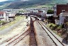
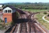 bpm00761.jpg |
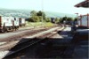
BAL POR |
Llynfi (Bridgend West junction & Cymmer Afan) and Porthcawl | South elevation of Tondu junction and signal box showing single line to Ogmore and Garw branches and converging single lines from Margam and Bridgend in foreground. The line to Maesteg runs straight ahead alongside the wagons in the siding. Tondu locoshed once stood in the field area beyond the junction | Footbridge at Tondu station, signal box and junction |
2 0 |
69 01 |
South | 07-May-89 | 16.11 |
 bpm00762.jpg |
GNT | Garnant | Looking south-west from the site of the former Ammanford colliery halt. | Former Ammanford colliery halt, Betws | 11 | 36 | NE | 24-Jun-89 | 17.26 |
 bpm00763.jpg |
GNT | Garnant | Looking north-east from the site of the former Ammanford colliery halt. The down fixed distant signal for Ammanford signal box is just visible in the distance | Former Ammanford colliery halt, Betws | 11 | 37 | SW | 24-Jun-89 | 17.26 |
 bpm00764.jpg |
GNT | Garnant | Looking south-west from Ammanford level crossing towards Pantyffynnon. The level crossing is now closed and a road deviation implemented | Ammanford Level Crossing | 11 | 06 | NE | 24-Jun-89 | 17.33 |
 bpm00765.jpg |
GNT | Garnant | Looking north-east from the south end of the former Ammanford station. The left-hand single line runs to Gwaun-cae-gurwen and the right-hand single line served Betws drift mine. | Former Ammanford station & signal box | 11 | 07 | South | 24-Jun-89 | 17.34 |
 bpm00766.jpg |
GNT | Garnant | Looking south-west towards Ammanford level crossing from the former station platform. As the two lines are separate single routes, the semaphore arms at the bracket signal apply to the individual lines, i.e. this is not a junction signal. | Former Ammanford station | 11 | 12 | North | 24-Jun-89 | 17.35 |
 bpm00767.jpg |
GNT | Garnant | Looking north east from the Garnant Branch level crossing at Pantyffynnon. The lines at the area where the wagons are stabled used to connect with an engine shed | Garnant Branch Level Crossing Pantyffynnon new yard | 10 | 17 | SW | 24-Jun-89 | 17.42 |
 bpm00768.jpg |
GNT | Garnant | Looking south-west from the Garnant Branch level crossing just north of Pantyffynnon station . The diesel locos serving the coal traffic on the branch are seen in the distance | Garnant Branch Level Crossing, Pantyffynnon station | 10 | 17 | NE | 24-Jun-89 | 17.42 |
 bpm00769.jpg |
GNT | Garnant | Looking north-east towards the level crossing on the Garnant Branch from the out-of-use platform at Pantyffynnon station | Pantyffynnon station (former Garnant Branch platform) | 10 | 09 | SW | 24-Jun-89 | 17.44 |
 bpm00770.jpg |
GNT | Garnant | Looking south-west towards Pantyffynnon junction and signal box from the out-of-use Garnant Branch platform of Pantyffynnon station | Pantyffynnon station (former Garnant Branch platform) | 10 | 08 | NE | 24-Jun-89 | 17.44 |
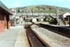
 bpm00771.jpg |
LLA | Llanelli & Llandeilo | Looking south along the Central Wales single line at Pantyffynnon station. The junction for the Garnant branch lies alongside Pantyffynnon signal box in the distance | Pantyffynnon station (Central Wales Line platform) | 10 | 08 | North | 24-Jun-89 | 17.45 |
 bpm00772.jpg |
LLA | Llanelli & Llandeilo | Looking north along the platform of Pantyffynnon station | Pantyffynnon station (Central Wales Line platform) | 10 | 08 | South | 24-Jun-89 | 17.45 |
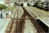
 bpm00773.jpg |
LLA GNT |
Llanelli & Llandeilo and Garnant branch | Looking south towards Pantyffynnon junction and signal box with Garnant branch joining from left | Pantyffynnon junction & signal box (South end of station) | 10 | 03 | North | 24-Jun-89 | 17.46 |
 bpm00774.jpg |
LLA GNT |
Llanelli & Llandeilo and Garnant branch | Pantyffynnon junction & signal box (South end of station) | 10 | 04 | North | 24-Jun-89 | 17.46 | |
 bpm00775.jpg |
GNT | Garnant | Looking north-east from the former Garnant Branch platform at Pantyffynnon station. The locos were stabled for Gwaun-cae-gurwen coal traffic workings and note that the two class 08 locos have cut-down cabs indicating that they had been in use on the Burry-port & Gwendraeth Valley branch | Pantyffynnon station (former Garnant Branch platform) | 10 | 05 | SW | 24-Jun-89 | 17.47 |
 bpm00776.jpg |
LLA | Llanelli & Llandeilo | Looking north towards Ammanford from level crossing at the north end of Pantyffynnon station. The Start of Token Section board is on the right. Sidings on the left previously ran onto the Mountain Branch and served a lime works quarry and Cross Hands, Llandebie and other collieries and finally Wernos (British Coal) | Pantyffynnon level crossing & groundframe | 10 | 11 | South | 24-Jun-89 | 17.47 |
 bpm00777.jpg |
THT | Treherbert | View of simplified junction layout at Porth station with out-of-use single line to Maerdy on left | Road overbridge North West of Porth station | 16 | 17 | NW | 25-Jun-89 | 14.25 |
 bpm00778.jpg |
MDY | Maerdy | Out-of-use single line at road overbridge north-east of Porth junction and station showing traps in line and also a 3-ft stop semaphore signal | Porth station. Road overbridge North East of junction | 16 | 21 | SE | 25-Jun-89 | 14.26 |
 bpm00779.jpg |
THT | Treherbert | View looking towards Tonypandy from road overbridge near Porth station, showing severed former up line | Road overbridge North West of Porth station | 10 | 17.5 | SE | 25-Jun-89 | 14.27 |
 bpm00780.jpg |
MDY | Maerdy | Looking towards Porth junction from the Maerdy branch showing 3-ft down home signal and road overbridge. By January 2007, the complete line had been lifted and a new trunk road interchange was being established here but was already sitting on the trackbed to the north-west and opened to road traffic towards Ferndale | Approach to Porth station from Maerdy branch | 16 | 23.5 | North | 25-Jun-89 | 14.29 |
 bpm00781.jpg |
MDY | Maerdy | The mothballed single line looking south towards Porth from a road overbridge south of Ynyshir. By late 2006, a new trunk road was laid on this alignment and was open to road traffic | Road overbridge between Porth & Ynyshir (former Lady Lewis colliery area) | ~16 | 60 | North | 25-Jun-89 | 14.39 |
 bpm00782.jpg |
MDY | Maerdy | The mothballed single line looking towards Porth from a road overbridge south of Ynyshir. By late 2006, a new trunk road was laid on this alignment and was open to road traffic | Road overbridge between Porth & Ynyshir (Lady Lewis colliery) | ~16 | 60 | South | 25-Jun-89 | 14.45 |
 bpm00783.jpg |
MDY | Maerdy | The mothballed single line looking towards Ynyshir from a road overbridge south of Ynyshir. The track passes over the river Rhondda Fach here and Ynyshir station used to lie just beyond the road overgbridge seen in the distance. By late 2006, a new trunk road was laid on this alignment and was open to road traffic | Former Ynyshir station | 17 | 11.5 | North | 25-Jun-89 | 14.54 |
 bpm00784.jpg |
MDY | Maerdy | Looking north at the site of the former Ynyshir station from a road overbridge. This scene is now susperseded by a new trunk road which was open to road traffic by late 2006 | Former Ynyshir station | 17 | 11.5 | South | 25-Jun-89 | 14.54 |
 bpm00785.jpg |
MDY | Maerdy | Looking south at the mothballed single line alongside a factory at Pontygwaith. The factory had been demolished and a new trunk road was partly open on revisiting the site in January 2007 | Road overbridge connecting B4277 road, Pontygwaith | 18 | 25.8 | North | 25-Jun-89 | 15.30 |
 bpm00786.jpg |
MDY | Maerdy | Looking north from the B4277 road overbridge immediately south of the former Maerdy station where the track is still visible. The line beyond fanned out into sidings for the former Maerdy colliery complex. The overbridge was later removed and the road re-aligned | Site of former Maerdy station and signal box | 22 | 40 | South | 25-Jun-89 | 15.47 |
 bpm00787.jpg |
MDY | Maerdy | View looking towards the site of the former Maerdy station and signal box, and beyond, the trackbed of the sidings complex for the Maerdy colliery. The bridge from where this record was taken, no longer exists due to a road re-alignment scheme | B4277 Maerdy-Aberdare road overbridge, Maerdy | 22 | 40 | NW | 25-Jun-89 | 15.51 |
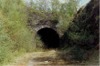
 bpm00788.jpg |
MER | Merthyr | South West portal of Merthyr Tunnel from 3M-37.25C to 4M-70.75C | 3 | 37.3 | SW | 25-Jun-89 | 16.45 | |
 bpm00789.jpg |
MER | Merthyr | South West portal of Merthyr Tunnel from 3M-37.25C to 4M-70.75C | 3 | 37.3 | SW | 25-Jun-89 | 16.46 | |
 bpm00790.jpg |
MER | Merthyr | Former site of Werfa loop | 25-Jun-89 | 16.48 | ||||
 bpm00791.jpg |
MER | Merthyr | West end of former Abernant station platform | 2 | 40.5 | East | 25-Jun-89 | 16.55 | |
 bpm00792.jpg |
MER | Merthyr | Former Abernant station & level crossing | 2 | 39 | West | 25-Jun-89 | 16.55 | |
 bpm00793.jpg |
THT | Treherbert | Porth station, footbridge and groundframe seen from platform level. The right-hand platform was out of use as was the line branching right to Maerdy | Porth station | 16 | 10 | SE | 02-Jul-89 | 09.28 |
 bpm00794.jpg |
THT | Treherbert | Porth station looking north from footbridge. Porth groundframe sits at the end of the left platform and the used crossing takes passenger traffic to the single line Treherbert branch. The further junction for the Maerdy branch was not in use as the line to Maerdy was by then mothballed and later lifted and a new trunk road had been established on the trackbed and was open to road traffic in December 2006, as far as Ferndale | Footbridge at Porth station | 16 | 12 | SE | 02-Jul-89 | 09.30 |
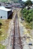
 bpm00795.jpg |
MDY | Maerdy | The mothballed single line Maerdy branch looking toward Ynyshir from just north of Porth. A new trunk road was established here during 2006 and was open to road traffic by year end | Just North of Porth station (Maerdy Branch) | 16 | 28 | South | 02-Jul-89 | 09.35 |
 bpm00796.jpg |
MDY | Maerdy | Looking towards Ynyshir from the B4277 road overbridge south of Wattstown (later the A4277). In January 2007, the bridge was about to be replaced as the track bed was by then re-used for a new trunk road up to this point, part of the Porth relief road project (See later photo) | B4277 Porth-Maerdy overbridge south of Wattstown | ~17 | 48 | NW | 02-Jul-89 | 09.41 |
 bpm00797.jpg |
MDY | Maerdy | Looking towards Pontygwaith and Wattstown from the B4277 road overbridge (Later the A4277). By May 2007, the bridge was demolished as the track bed was by then re-used for a new trunk road up to this point, part of the Porth relief road project (See later photo) | B4277 Porth-Maerdy overbridge south of Wattstown | ~17 | 48 | SE | 02-Jul-89 | 09.42 |
 bpm00798.jpg |
MDY | Maerdy | Looking north-west from a foot crossing, south of Wattstown, towards the B4277 road overbridge. In January 2007, the new Maerdy valley trunk road was being laid on this trackbed and the bridge was sealed off pending removal and renewal for the new roadworks and by May, the bridge had been removed | Between Pontygwaith and Wattstown | ~17 | 40 | SE | 02-Jul-89 | 09.45 |
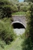
 bpm00799.jpg |
VON | Neath (General) & Pontypool Road | West portal of 526-yd Pencaedrain tunnel. (Limits 28M-64.5C to 29M-08.5C) | Pencaedrain Tunnel West portal | 29 | 10 | West | 03-May-90 | 15.24 |
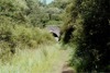
 bpm00800.jpg |
VON | Neath (General) & Pontypool Road | Trackbed immediately west of west portal of Pencaedrain tunnel | Pencaedrain Tunnel West portal | 29 | 10 | East | 03-May-90 | 15.25 |
| 701-750 <- |
Photos 751-800 |
-> 801-850 | |||||||
|
Date Last Revised:November 30, 2009 |
|||||||||