|
Historical Railway Photograph Gallery 1651-1700 |
|||||||||
|
Photos 1651-1700 |
|||||||||
| Photo | ELR | Branch | Subject | Location | M | C | Elev'n | Date | Time |
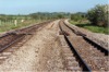
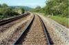
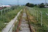
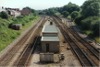
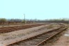 bpm01651.jpg |
ELY | Ely Valley | General view of Llantrisant yard with most lines out of use | Llantrisant Yard | ~0 | 38 | West | 06-May-89 | 16.14 |
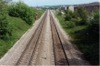
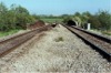
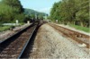
 bpm01652.jpg |
SWM | Severn Tunnel Jct & Fishguard Harbour | Looking towards Cardiff from B4270 Road overbridge east of Former Llantrisant station | B4270 Road overbridge east of Llantrisant station | ~181 | 10 | West | 06-May-89 | 16.55 |
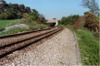
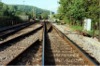
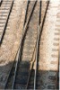
 bpm01653.jpg |
SWM | Severn Tunnel Jct & Fishguard Harbour | Up & down main line east of Stormy loop, showing chevroned SHC rail fixings on concrete sleepers | Between Stormy Sidings & Bridgend, west of M4 motorway overbridge | 194 | 35 | West | 18-May-91 | 15.35 |
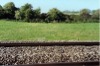
 bpm01654.jpg |
SWM POR |
Severn Tunnel Jct & Fishguard Harbour / Porthcawl | Looking south-east from trackbed of former Porthcawl branch just east of where Pyle station stood | Former double line from Tondu at area just east of removed Pyle station and junction |
195 5 |
68 69 |
SE | 18-May-91 | 16.11 |
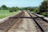
 bpm01655.jpg |
SWM | Severn Tunnel Jct & Fishguard Harbour | Looking south-east along the South Wales main line at a point 4 chains north-west of where Pyle West Loop junction and signal box was located until the mid-'sixties The west loop ran to the right to a junction with the Porthcawl branch at Heol-y-Sheet. In the distance can be seen a footbridge where the new Pyle station is now located. | Unclassified road overbridge west of site of Margam end of PyleWest Loop | 197 | 55 | West | 18-May-91 | 16.31 |
 bpm01656.jpg |
SWM | Severn Tunnel Jct & Fishguard Harbour | Looking south-east along the South Wales main line at a point 5� chains north-west of where Pyle West Loop junction and signal box was located until the mid-'sixties | Just west of unclassified road overbridge west of former junction to Pyle West loop | 197 | 56.5 | West | 18-May-91 | 16.32 |
 bpm01657.jpg |
SWM | Severn Tunnel Jct & Fishguard Harbour | Looking south-east along the South Wales main line at A48 road overbridge, Pyle | Pyle A48 road overbridge (West of former Pyle Station) | 196 | 12 | West | 18-May-91 | 16.47 |
 bpm01658.jpg |
VOG | Vale of Glamorgan | Looking west towards Rhoose cement works and down siding. The cement works site is now a housing estate, the down siding is removed and in 2004, a new Rhoose station with staggered platforms was opened to serve the community and Cardiff Airport. Note the Spring Catchpoint sign on the right of the up line. | East of Rhoose cement works | 2 | 52 | NE | 19-May-91 | 09.30 |
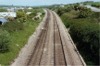
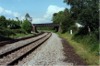
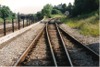
 bpm01659.jpg |
SWM | Severn Tunnel Jct & Fishguard Harbour | General elevation of up & down main line at agricultural crossing illustrating Pandrol fixed track on reinforced concrete sleepers. Up line was in 110A section, down was in 113A section at this point | St.Georges | 175 | 41 | West | 20-May-91 | 18.13 |
 bpm01660.jpg |
SWM | Severn Tunnel Jct & Fishguard Harbour | Up & Down main line at River Ely bridge, St.Georges. Bridge was built by Fairford of Chepstow (built 1954). Track is Pandrol-fixed on reinforced concrete sleepers. Down line is in 113A section, up line is in 110A section | River Ely bridge, near St.Georges | 175 | 27 | West | 20-May-91 | 18.18 |
 bpm01661.jpg |
SWM | Severn Tunnel Jct & Fishguard Harbour | Looking east towards St Fagans, showing the Culverhouse Cross-M4 link road overbridge which replaced the former Barry Railway's arched viaduct at that location | Just west of Culverhouse Cross-M4 link road overbridge. | 175 | 05.5 | West | 20-May-91 | 18.25 |
 bpm01662.jpg |
SWM SFA |
Severn Tunnel Jct & Fishguard Harbour / St.Fagans branch | Looking north towards a surviving field-to-field railway overbridge on the former St.Fagans - Tynycaeau single line. The later Culverhouse Cross-M4 motorway link road on the former Barry Railway's trackbed, lies behind the distant fencing | Opposite field access rail overbridge on former St.Fagans branch (Viewed from South Wales Main line) |
175 0 |
08 30 |
South | 20-May-91 | 18.27 |
 bpm01663.jpg |
SWM | Severn Tunnel Jct & Fishguard Harbour | Looking east towards St Fagans, showing the Culverhouse Cross-M4 link road overbridge which replaced the former Barry Railway's arched viaduct at that location. The wide-spanned steel bridge visible just beyond, was for agricultural access to fields either side of the railway and linked with the brick-arched overbridge shown in frame 01664 | Just west of Culverhouse Cross-M4 link road overbridge. | 175 | 04 | West | 20-May-91 | 18.28 |
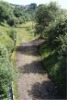
 bpm01664.jpg |
SFA | Severn Tunnel Jct & Fishguard Harbour | Field-to-field overbridge over former St.Fagans branch incline to Tynycaeau Jct from St.Fagans junction | Alongside Culverhouse Cross-M4 link road overbridge. | 0 | 34.5 | West | 20-May-91 | 18.35 |
 bpm01665.jpg |
SWM | Severn Tunnel Jct & Fishguard Harbour | Up & down South Wales main lines viewed from Culverhouse Cross-M4 link road overbridge west of St. Fagans. The former St.Fagans branch trackbed incline is seen on the left. | Culverhouse Cross-M4 link road overbridge. | 175 | 01 | West | 20-May-91 | 18.35� |
 bpm01666.jpg |
SFA | St.Fagans junction & Tynycaeau junction (Ex Barry Railway) | Inclined trackbed of former St.Fagans branch between St.Fagans Jct & Tynycaeau Jct | Field-to-field access rail overbridge on former St.Fagans branch (Viewed from South Wales Main line) | 0 | 35 | West | 20-May-91 | 18.36 |
 bpm01667.jpg |
SWM | Severn Tunnel Jct & Fishguard Harbour | Up & down South Wales main line west of St.Fagans level crossing | �-mile west of St.Fagans level crossing | 175 | 00 | West | 20-May-91 | 18.40� |
 bpm01668.jpg |
SWM | Severn Tunnel Jct & Fishguard Harbour | View of up & down main near St.Fagans level crossing showing out-of-use facing crossover with crossings removed from up and down main. Rail sections are 113A flat bottom with reinforced concrete sleepers. Crossover is Pandrol fixed as is plain line. Crossing has been removed from 6- foot side of lines | St.Fagans level crossing | 174 | 41 | SW | 20-May-91 | 18.54 |
 bpm01669.jpg |
SWM | Severn Tunnel Jct & Fishguard Harbour | Elevation of up & down main at St.Fagans level crossing showing former facing crossover with crossing now removed and plain-lined but points drive still intact. Rail sections are 113A flat bottom with Pandrol fixings on standard chair screws on timber | St.Fagans level crossing | 174 | 38 | SW | 20-May-91 | 18.55 |
 bpm01670.jpg |
SFA | St.Fagans junction & Tynycaeau junction (Ex Barry Railway) | Rail overbridge over part of the former split section of the river Ely, west of St.Fagans level crossing. This bridge carried the single line branch from St.Fagans junction to Tynycaeau junction on the former Barry-Pontypridd line and the line was taken out-of-use in the 1960's | West of St.Fagans | 174 | 58 | South | 20-May-91 | 19.04 |
 bpm01671.jpg |
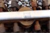
CAM | Cardiff (Bute Rd) & Merthyr | Plan view on Continuous Welded Rail weld illustrating fissure and emergency CWR clamp plates with "G"-clamp fixings | Treforest Trading Estate Halt, down main | 9 | 47 | Plan | 23-May-91 | 18.55 |
 bpm01672.jpg |
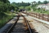
SWM | Severn Tunnel Jct & Fishguard Harbour | View of up & down main at Groesfaen foot crossing showing Pandrol-fixed flat-bottom rails on reinforced concrete sleepers. Up line is 110A section, down line is in 113A section | Groesfaen foot crossing, Peterston West | 177 | 22.25 | West | 04-Jun-91 | 18.00 |
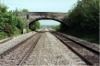
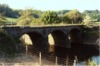
 bpm01673.jpg |
SWM | Severn Tunnel Jct & Fishguard Harbour | View of bridge No.181 at location of former junction to Drope (Ex Barry Railway)( junction taken out in 1960's). Illustration shows up & down main line at approximate location of former Peterston-Super-Ely Station (Main line) | Peterston-Super-Ely | 170 | 75 | West | 04-Jun-91 | 18.09� |
 bpm01674.jpg |
PHB | Penarth Harbour | The last of the low level lines which finally served the Taff Wagon Co's works at what is now Ferry Road, Grangetown. The incline seen, falls down from Ferry Rd Low Level jct and was completely removed later and by 2007 had been built on | Ferry road, Grangetown | ~1 | 32 | South | 06-Jul-91 | 11.10 |
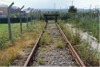
 bpm01675.jpg |
PHB | Penarth Harbour | The last remnant of the Penarth Harbour branch, finally serving as an unloading point for tank traffic for BP Oil. All now completely removed and entire branch lifted | Buffer stop at former BP Oil unloading siding, Ferry road | 1 | 52 | North | 06-Jul-91 | 11.14 |
 bpm01676.jpg |
PHB | Penarth Harbour | The last remnant of the Penarth Harbour branch, finally serving as an unloading point for tank traffic for BP Oil. All now completely removed and entire branch lifted | Former BP Oil unloading siding Ferry Rd | 1 | 51 | South | 06-Jul-91 | 11.14 |
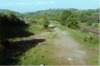
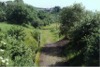
 bpm01677.jpg |
PTH | Penarth | Trackbed under grass west of former Swanbridge Halt. Some of the ballasted bed is visible in the distance at the site of the former halt | West of former Swanbridge Halt | ~4 | 05 | East | 08-Jul-91 | 11.30 |
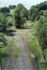
 bpm01678.jpg |
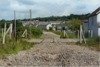
BJR | Bassaleg Jct & New Tredegar | View of trackbed of former Newport/Brecon line at Aberbargoed junction site | Road overbridge at former Aberbargoed Jct (now completely removed) | 15 | 12 | North | 08-Jul-91 | 15:23 |
 bpm01679.jpg |
BJR | Bassaleg Jct & New Tredegar | View of trackbed of former Newport/Brecon line at Aberbargoed junction site | Road overbridge at former Aberbargoed Jct (now completely removed) | 15 | 12 | North | 08-Jul-91 | 15:23 |
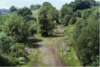 bpm01680.jpg |
BJR | Bassaleg Jct & New Tredegar | View of Aberbargoed Jct site with former Bargoed Loop to left and New Tredegar line to right | Road overbridge at former Aberbargoed Jct (now completely removed) | 15 | 12 | South | 08-Jul-91 | 15:23 |
 bpm01681.jpg |
BJR | Bassaleg Jct & New Tredegar | View of Aberbargoed Jct site with former Bargoed Loop to left and New Tredegar line to right | Road overbridge at former Aberbargoed Jct (now completely removed) | 15 | 12 | South | 08-Jul-91 | 15:23 |
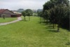
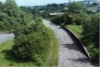 bpm01682.jpg |
PEN | Halls Rd & Markham Colliery | The up platform of the former Penmaen halt after track lifting of the Penar branch. By year end 2006, the entire track bed here had been backfilled and remodelled to accommodate a new road scheme from the Markham area to Pontllanfraith. | Former Penmaen halt (B4251 road overbridge) up platform | 5 | 75 | North | 08-Jul-91 | 15:45 |
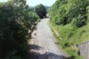 bpm01683.jpg |
PEN | Halls Rd & Markham Colliery | The down up platform of the former Penmaen halt after track lifting of the Penar branch. By year end 2006, the entire track bed here had been backfilled and remodelled to accommodate a new road scheme from the Markham area to Pontllanfraith. | Former Penmaen halt (B4251 road overbridge) down platform | 5 | 75 | South | 08-Jul-91 | 15:45 |
 bpm01684.jpg |
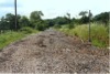
PEN | Halls Rd & Markham Colliery | Looking north-west along the trackbed of the lifted Penar branch just north-west of the former Penar junction and crossing keeper's house | Just west of former level crossing on Penar branch near Penar junction | 4 | 67.5 | SE | 08-Jul-91 | 15.50 |
 bpm01685.jpg |
PEN | Halls Rd & Markham Colliery | The site of the level crossing alongside the crossing keeper's house at Penar. The branch ceased to operate after 1989 and the track was lifted, and re-usable flatbottom rails were recovered for use elsewhere | Just west of former level crossing on Penar branch near Penar junction | 4 | 67.5 | NW | 08-Jul-91 | 15:50 |
 bpm01686.jpg |
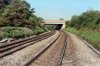
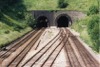
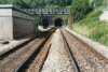
SWM | Severn Tunnel Jct & Fishguard Harbour | South portals of Newport tunnels viewed from a pedestrian footbridge. The crossovers from the relief lines (right) to the main lines (left) were removed during 2006. Newport new tunnel (left) is 770-yd long and the old one (right), 748-yd | Gaer junction, Newport | 159 | 31 | South | 08-Jul-91 | 16:26 |
 bpm01687.jpg |
SWM GAE |
Severn Tunnel Jct & Fishguard Harbour / Gaer | Looking south from a footbridge just south ot Newport tunnels, with the relief lines on the left and the main lines on the right. The Gaer branch on the right is single beyond the points on the incline. | Gaer junction, Newport | 159 | 31 | North | 08-Jul-91 | 16:26 |
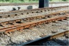
 bpm01688.jpg |
SWM | Severn Tunnel Jct & Fishguard Harbour | A cast manganese diamond crossing in the permanent way just south of Newport tunnels | Adjacent to Gaer junction | 159 | 31 | Plan | 08-Jul-91 | 16:27 |
 bpm01689.jpg |
GAE | Gaer Jct & Park Jct | Looking towards Gaer tunnel, Newport where the double line runs into a single line from here to Park junction on the Western Valleys line | Single line junction north east of Gaer tunnel portal | 159 | 40 | North | 08-Jul-91 | 16:35 |
 bpm01690.jpg |
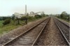
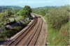
SWM | Severn Tunnel Jct & Fishguard Harbour | Looking south along the South Wales Main line with the relief lines on the right with the A48 road bridge in the distance | Adjacent to Gaer junction, Newport | 159 | 43 | North | 08-Jul-91 | 16:36 |
 bpm01691.jpg |
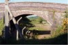
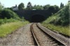
GAE | Gaer Jct & Park Jct | Looking west towards the east portal of 403-yd Gaer tunnel whose limits are 159M-47C to 159M-65C | Gaer east tunnel portal | 159 | 45.5 | NE | 08-Jul-91 | 16:37 |
 bpm01692.jpg |
GAE | Gaer Jct & Park Jct | Single to double line junction on Gaer branch showing Newport west tunnel portals and Gaer junction beyond | Gaer branch (Gaer junction end) | 159 | 43 | South | 08-Jul-91 | 16:37 |
 bpm01693.jpg |
GAE SWM |
Gaer /Severn Tunnel Jct & Fishguard Harbour | Looking north-east towards Newport tunnels from the Gaer Branch. The crossovers just beyond the communications building leading from the main to relief lines, were removed during 2006 | Gaer junction, Newport | 159 | 34 | South | 08-Jul-91 | 16:38 |
 bpm01694.jpg |
SWM GAE | Severn Tunnel Jct & Fishguard Harbour / Gaer | Diamond crossing in down main, Gaer junction | Gaer junction, Newport | 159 | 36 | West | 08-Jul-91 | 16:42 |
 bpm01695.jpg |
SWM | Severn Tunnel Jct & Fishguard Harbour | Looking along the relief lines towards the south portals of Newport tunnels. The full bore of the right-hand tunnel is visible | Down relief lines at Gaer junction, south of Newport tunnels | 159 | 34.5 | South | 08-Jul-91 | 16:46 |
 bpm01696.jpg |
GAE | Gaer Jct & Park Jct | Looking towards Park junction from the road passing above the West portal of Gaer tunnel, Newport | Above west portal of Gaer tunnel, Newport | 159 | 65 | East | 08-Jul-91 | 17:00 |
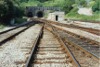
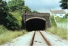 bpm01697.jpg |
GAE | Gaer Jct & Park Jct | West portal of 403-yd Gaer tunnel, Newport | Just west of Gaer tunnel, west portal | 159 | 66 | West | 08-Jul-91 | 17:02 |
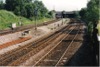
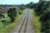
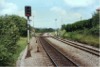 bpm01698.jpg |
SWM | Severn Tunnel Jct & Fishguard Harbour | View of St.Georges level crossing showing Cardiff Panel signal CF101 | Cardiff Panel up main signal, CF101 | 175 | 62.5 | West | 08-Jul-91 | 17:59 |
 bpm01699.jpg |
SWM | Severn Tunnel Jct & Fishguard Harbour | Up & down main lines just west of St.Georges level crossing, Cardiff Panel signal CF101 and River Ely bridge | West of St.Georges level crossing | 175 | 66 | West | 08-Jul-91 | 18:00 |
 bpm01700.jpg |
SWM | Severn Tunnel Jct & Fishguard Harbour | View looking towards St Georges east of former Peterston east loop which tied in with the lifted Barry sidings connecting the Peterston-Drope Jct single line which in turn, connected with the Cadoxton-Trehafod branch of the former Barry Railway | East of former Peterston East loop junction | 176 | 08 | West | 08-Jul-91 | 18:08 |
|
Photos 1651-1700 |
|||||||||
|
Date Last Revised:November 30, 2009 |
|||||||||