|
Historical Railway Photograph Gallery 2251-2300 |
|||||||||
|
Photos 2251-2300 |
|||||||||
| Photo | ELR | Branch | Subject | Location | M | C | Elev'n | Date | Time |
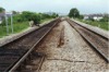
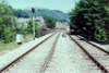
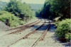
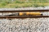 bpm02251.jpg |
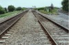
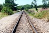
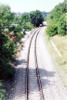
CPL | Penarth Curve | View of Automatic Warning magnet unit in track | Between Penarth Curve South junction and Ninian Park halt | East | ||||
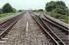
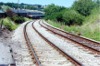
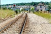
 bpm02252.jpg |
RAD | Radyr | Up & down single line for City Line service running between Ninian Park Halt and Cardiff Central stations | South of Ninian Park halt and south-west of Cardiff, Canton DM shed | West | ||||
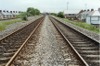
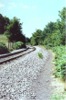
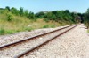
 bpm02253.jpg |
CLL | Leckwith Loop | Up & down link between South Wales Main line and Radyr lines | Leckwith Loop single line | 0 | 13 | East | ||
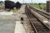
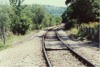
 bpm02254.jpg |
SWM | Severn Tunnel Jct & Fishguard Harbour | East elevation of South Wales Main lines with Leckwith Loop North junction line trailing into down main and showing crossover from up to down main lines | Leckwith Loop North junction |
171 0 |
55 00 |
East | ||
 bpm02255.jpg |
SWM | Severn Tunnel Jct & Fishguard Harbour | West elevation from Leckwith Loop North junction showing up and down South Wales main and relief lines and Leckwith Loop single line | Leckwith Loop North junction | 171 | 53 | West | ||
 bpm02256.jpg |
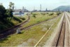
SWM | Severn Tunnel Jct & Fishguard Harbour | Facing crossover in South Wales down to up main, principally for up SW traffic to cross over and enter single line Leckwith loop line from the west | Broad St road underbridge, Cardiff | 171 | 63.75 | East | ||
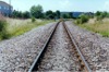
 bpm02257.jpg |
SWM | Severn Tunnel Jct & Fishguard Harbour | Up & down main line with little-used trailing crossover. Ely Paper mill in the distance, was later demolished and its site still void in 2007 | Broad St road underbridge, Cardiff | 171 | 63.75 | East | ||
 bpm02258.jpg |
SWM | Severn Tunnel Jct & Fishguard Harbour | Up & Down main lines and crossover from up to down main | West of Leckwith Loop North junction | 171 | 60 | East | ||
 bpm02259.jpg |
SWM | Severn Tunnel Jct & Fishguard Harbour | Up & Down main lines and crossover from up to down main | Leckwith Loop North junction |
0 171 |
00 48 |
East | ||
 bpm02260.jpg |
SWM | Severn Tunnel Jct & Fishguard Harbour | Up & Down main lines and turnout to Penarth curve south/Radyr line link. Up & down relief loops shown to east of view | Leckwith Loop North junction |
0 171 |
00 48 |
West | ||
 bpm02261.jpg |
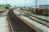
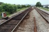
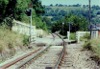
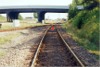
RAD | City Line | Up & down main lines west of Leckwith loop jct-south | West of Leckwith Loop South junction | East | ||||
 bpm02262.jpg |
RAD | City Line | Up & down main lines west of Leckwith loop jct-south. Ninian Park halt is situated beyond the single line junction and the road underbridge in the distance | West of Leckwith Loop South junction | 0 | 73 | West | ||
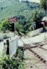
 bpm02263.jpg |
RAD | City Line | Trailing crossover & ground signal at east end of Ninian Park halt | Ninian Park halt | 0 | 60 | West | ||
 bpm02264.jpg |
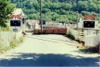
PHB | Penarth Harbour | View of loop section of line to former Penarth harbour area (All lifted by year 2003) | South-east of Grangetown station | 1 | 00 | NW | ||
 bpm02265.jpg |
BRY PHB |
Barry & Penarth Harbour Bch | Lead from down main Barry line to Penarth Harbour branch | Penarth Harbour Jct, Grangetown station, | 0 | 70 | SE | ||
 bpm02266.jpg |
PHB | Penarth Harbour | View of SE end of Harbour Branch loop (All lifted by year 2003) | NW of Ferry Road overbridge (now removed) | 1 | 22 | SE | ||
 bpm02267.jpg |
PHB | Penarth Harbour | View of junction to former harbour lines | Ferry Road overbridge (now removed) | 1 | 23 | NW | ||
 bpm02268.jpg |
PHB | Penarth Harbour | View of junction to former harbour lines | Ferry Road junction (now extinct) | 1 | 25.5 | SE | ||
 bpm02269.jpg |
PHB | Penarth Harbour | View of junction to former harbour lines | Ferry Road junction (now extinct) | 1 | 26.5 | SE | ||
 bpm02270.jpg |
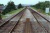
RAD | City Line | View of double track at Ely Road underbridge | South-east of Waun Gron Park halt | 2 | 16.5 | NW | ||
 bpm02271.jpg |
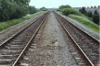
RAD | City Line | View of double track looking towards Waun Gron Park halt | South-east of Western Ave underbridge | 2 | 17 | SE | ||
 bpm02272.jpg |
RAD | City Line | View of double track looking towards Fairwater Halt. | North end, Waun Gron Park halt | 2 | 28 | SE | ||
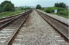
 bpm02273.jpg |
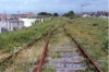
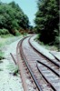
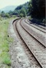
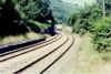
HRD | Lime Kiln junction & Penar | Single line reverse curve and viaduct guard rail ends at viaduct. Replacement rails are prominent but were not laid as branch was closed shortly after this record was taken. | North side of Halls viaduct (Cwmcarn) | 2 | 72 | South | ||
 bpm02274.jpg |
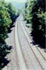
WVL | Park jct & Aberbeeg | Up & down Western Valleys double line as seen from Halls viaduct near Cwmcarn | Halls viaduct, Cwmcarn | 7 | 63 | South | ||
 bpm02275.jpg |
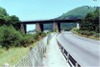
HRD | Lime Kiln junction & Penar | Southern elevation of Halls viaduct spanning A467 trunk road, river Ebbw and Western Valleys lines. The line over the viaduct, running to Penar Jct and Oakdale colliery, was closed in 1989 | Halls viaduct, north of Crosskeys (Runs from 1M-08C to 1M-15C) | 1 | 15 | South | ||
 bpm02276.jpg |
WVL | Park jct & Aberbeeg | Former Cwmcarn station 77-yard platforms on Western Valleys line, looking south-east | Former Cwmcarn station | 8 | 17 | NW | ||
 bpm02277.jpg |
WVL | Park jct & Aberbeeg | Former Cwmcarn station 77-yard platforms on Western Valleys line, looking north-west | Former Cwmcarn station | 8 | 17 | SE | ||
 bpm02278.jpg |
HRD | Lime Kiln junction & Penar | Single line Halls Road branch between Halls viaduct and Newbridge (Line closed and lifted after 1989) | West side of valley between Abercarn and Cwmcarn | NW | ||||
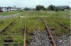
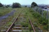
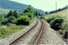
 bpm02279.jpg |
HRD | Lime Kiln junction & Penar | Single line Halls Road branch between Halls viaduct and Newbridge (Line closed and lifted after 1989) | West side of valley between Abercarn and Cwmcarn | SE | ||||
 bpm02280.jpg |
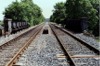
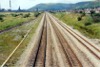
WVL | Park jct & Aberbeeg | Up & down main Western Valleys lines, north of signal DM8R | Abercarn | 9 | 20.5 | North | ||
 bpm02281.jpg |
WVL | Park jct & Aberbeeg | Up & down main Western Valleys lines, at signal UM10R and Abercarn Road underbridge | Abercarn | 9 | 21 | South | ||
 bpm02282.jpg |
HRD | Lime Kiln junction & Penar | Looking down the steeply graded road at Pantyresk level crossing during the last weeks of the branch working to Oakdale colliery. In 2007 there was still evidence of there having been a rail crossing here although the line was closed in late 1989 and the line lifted afterwards | Pantyresk level crossing, Abercarn | 2 | 69 | West | ||
 bpm02283.jpg |
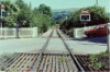
HRD | Lime Kiln junction & Penar | Looking upline at Pantyresk level crossing, Abercarn shortly before the branch was closed. Note the electric treadles in the track either side of the crossing. These were part of the flashing light control operation system | Pantyresk level crossing, Abercarn | 2 | 69 | South | ||
 bpm02284.jpg |
HRD | Lime Kiln junction & Penar | Looking downline at Pant-yr-Esk level crossing, Abercarn shortly before the branch ws closed | Pantyresk level crossing, Abercarn | 2 | 69 | North | ||
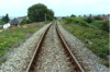
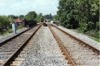
 bpm02285.jpg |
WVL | Park jct & Aberbeeg | Up & down main Western Valleys lines, south of former Newbridge station | South of former Newbridge station, alongside Celynen Road | ~10 | 00 | NW | ||
 bpm02286.jpg |
WVL | Park jct & Aberbeeg | Up & down main Western Valleys lines, approaching former Newbridge station | South of former Newbridge station, alongside Celynen Road | ~10 | 00 | SE | ||
 bpm02287.jpg |
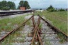
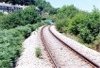
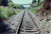
HRD | Lime Kiln junction & Penar | Steeply-graded single line reverse curve approaching Cwmdoes level crossing from south-east (Line closed in 1989 and lifted in this section) | South-west of Newbridge, Gwent | ~3 | 70 | SE | ||
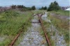
 bpm02288.jpg |
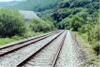
HRD | Lime Kiln junction & Penar | Improvised level crossing in single line between Cwmdoes level crossing and Abercarn (line closed in 1989 and lifted in this section) | South-west of Newbridge, Gwent | ~3 | 70 | West | ||
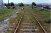
 bpm02289.jpg |
HRD | Lime Kiln junction & Penar | Looking east down the incline of the Halls Road branch at Cwmdoes level crossing, since removed | Cwmdoes level crossing, west of Newbridge, Gwent | 4 | 10 | West | ||
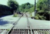 bpm02290.jpg |
HRD | Lime Kiln junction & Penar | Looking west towards Penar tunnel on the Halls Road branch, from Cwmdoes level crossing, since removed | Cwmdoes level crossing, west of Newbridge, Gwent | 4 | 10 | East | ||
 bpm02291.jpg |
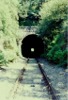
HRD | Lime Kiln junction & Penar | The west portal of the 239-yard Penar tunnel (From 4M-42C to 4M-53C) | Penar tunnel, west portal | 4 | 54 | West | ||
 bpm02292.jpg |
HRD | Lime Kiln junction & Penar | Single line looking west after exiting Penar tunnel and looking towards Penar junction. A level crossing warning board is seen along the track and applies to a level crossing on an unclassified lane at Penar | Approaching Penar junction | 4 | 54 | East | ||
 bpm02293.jpg |
PEN | Penar Jct & Oakdale colliery | Single line leaving Penar and looking towards Pontllanfraith (Line closed 1989 and lifted by 1990) | Penar junction level crossing | 4 | 67 | SE | ||
 bpm02294.jpg |
PEN | Penar Jct & Oakdale colliery | Single line and level crossing with former crossing keeper's house (Line closed in 1989 and lifted by 1990) | Penar junction level crossing | 4 | 67 | NW | ||
 bpm02295.jpg |
PEN VON |
Penar Jct & Oakdale colliery / Vale of Neath | Single line from Penar tunnel to Oakdale colliery viewed at former intersection with Vale of Neath line which passed through the cutting in the background. Line closed shortly after this record was taken. | Penar junction (intersection with former Vale of Neath lines) |
4 7 |
67 60 |
West | ||
 bpm02296.jpg |
PEN VON |
Penar Jct & Oakdale colliery / Vale of Neath | Single line to Oakdale colliery at point where line intersected Vale of Neath up & down main lines. The VON trackbed runs to the left from the camera point | Penar junction (intersection with former Vale of Neath lines) |
4 7 |
67 60 |
East | ||
 bpm02297.jpg |
PEN | Penar Jct & Oakdale colliery | Looking north towards Oakdale from the then B4251 road overbridge at the former Penmaen halt site which had staggered platforms. The area was completely remodelled by 2007 and a new road scheme constructed along the valley, taking in most of the former trackbed | Former Penmaen halt | 5 | 75 | South | ||
 bpm02298.jpg |
OVE SWM |
Ogmore Vale extension South Wales Main |
Looking south-east at Margam Yard junction and the main road access overbridge into Margam Abbey steelworks. The single OVE line connection leading to Copper Works junction (behind camera) was in mothball by 2004 after the cessation of iron-ore traffic from Port Talbot to Llanwern steelworks | Margam Yard junction |
0 200 |
79 63 |
North | 21-Jul-91 | 15.36˝ |
 bpm02299.jpg |
OVE SWM |
Ogmore Vale extension South Wales Main |
Looking north-west from the main road access overbridge to Margam Abbey steelworks. The down goods line is on the left and the up & down South Wales Main lines are to the right, the up goods being on the extreme right | Margam Yard junction |
0 200 |
79 63 |
South | 21-Jul-91 | 15.45 |
 bpm02300.jpg |
OVE SWM |
Ogmore Vale extension South Wales Main |
Looking west from the main road access overbridge to Margam Abbey steelworks. The single to double OVE lines leading to Copper works junction and the Port Talbot iron-ore terminal are on the extreme left. The down goods line and up & down South Wales Main lines are to the right | Margam Yard junction |
0 200 |
79 63 |
South | 21-Jul-91 | 15.46˝ |
|
Photos 2251-2300 |
|||||||||
|
Date Last Revised:December 02, 2009 |
|||||||||