|
Historical Railway Photograph Gallery 1551-1600 |
|||||||||
|
Photos 1551-1600 |
|||||||||
| Photo | ELR | Branch | Subject | Location | M | C | Elev'n | Date | Time |
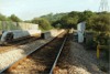
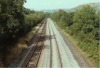
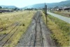
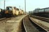 bpm01551.jpg |
SWA | Landore Jct & Swansea, High Street | View of carriage sidings and stabled tamping machines, Swansea | Carriage siding area, Swansea | NW | 11-Jul-91 | 17.34 | ||
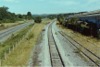
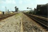 bpm01552.jpg |
SWA | Landore Jct & Swansea, High Street | View looking towards Swansea High St station from Swansea Branch and alongside carriage sidings | Swansea High Street, North End (ACE yard) | 215 | 56 | NW | 11-Jul-91 | 17.36 |
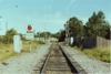
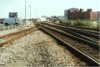 bpm01553.jpg |
SWA | Landore Jct & Swansea, High Street | North end of Swansea High St station showing siding which formerly went straight ahead beyond buffer stop on left, to link with Wind St Jct and the LMS lines to Central Wales. | Swansea High Street, North End (ACE yard) | 215 | 66 | 11-Jul-91 | 17.40 | |
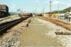 bpm01554.jpg |
SWA | Landore Jct & Swansea, High Street | View of carriage sidings fan and ACE yard , immediately north-east of Swansea High street station | Swansea High Street, North End | 215 | 66 | 11-Jul-91 | 17.40 | |
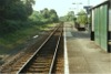 bpm01555.jpg |
CAM | Cardiff (Bute Rd) & Merthyr | Island platform, up side, Treforest Estate halt | Treforest Estate Halt | 9 | 53 | SE | 15-Jul-91 | 18.03 |
 bpm01556.jpg |
CAM | Cardiff (Bute Rd) & Merthyr | Island platform, down side, Treforest Estate halt | Treforest Estate Halt | 9 | 53 | NW | 15-Jul-91 | 18.03 |
 bpm01557.jpg |
CAM | Cardiff (Bute Rd) & Merthyr | View from mid-point of Treforest Estate halt, island platform, looking South-east towards Taffs Well | Treforest Estate Halt | 9 | 57 | NW | 15-Jul-91 | 18.06 |
 bpm01558.jpg |
CAM | Cardiff (Bute Rd) & Merthyr | View looking towards Taffs Well at Maesmawr road underbridge north-west of Treforest Estate halt | Maesmawr road underbridge, south of Upper Boat | 10 | 01 | NW | 15-Jul-91 | 18.12� |
 bpm01559.jpg |
CAM | Cardiff (Bute Rd) & Merthyr | View looking towards Taffs Well at Maesmawr road underbridge north-west of Treforest Estate halt | Maesmawr road underbridge, south of Upper Boat | 10 | 01 | SE | 15-Jul-91 | 18.12� |
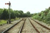
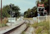
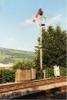 bpm01560.jpg |
CAM | Cardiff (Bute Rd) & Merthyr | Motored down advanced starting signal with track-circuit indicator. The lineside cabinets are associated with the track-circuit and semaphore motor power supply and relays | Down advanced starting signal Maesmawr, Upper Boat | 10 | 12 | West | 15-Jul-91 | 18.14 |
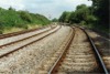
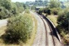
 bpm01561.jpg |
CAM | Cardiff (Bute Rd) & Merthyr | Looking north-west towards Treforest from a point north-west of Treforest Estate halt | South of Tonteg-Upper Boat road overbridge | 10 | 17 | SE | 15-Jul-91 | 18.19 |
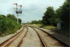
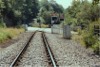
 bpm01562.jpg |
CAM | Cardiff (Bute Rd) & Merthyr | Looking south from a point south of Maesmawr signal box with down advanced starting signal visible. | Between Treforest station and Treforest estate halt | 10 | 17 | NW | 15-Jul-91 | 18.19 |
 bpm01563.jpg |
CAM | Cardiff (Bute Rd) & Merthyr | Ynyswern road underbridge between Upper Boat and Tonteg. The original bridge carried four tracks until the relief lines (previously on the right) were lifted after 1964 | Ynyswern road underbridge, Tonteg-Upper Boat road | 10 | 31 | West | 15-Jul-91 | 18.23 |
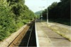
 bpm01564.jpg |
CAM | Cardiff (Bute Rd) & Merthyr | View looking towards Taffs Well at Willowford Rd underbridge south-east of Treforest Estate halt | Willowford Rd underbridge south of Treforest Estate halt | 9 | 12.25 | NW | 15-Jul-91 | 18.43 |
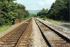
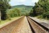
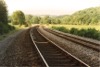
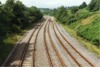
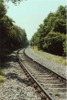
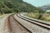
 bpm01565.jpg |
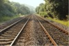
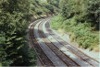
CAM | Cardiff (Bute Rd) & Merthyr | Up & down main lines showing reverse curve and transition. The former double relief lines ran on the right of those shown | West of Nantgarw | 9 | 09 | NW | 15-Jul-91 | 18.46 |
 bpm01566.jpg |
CAM | Cardiff (Bute Rd) & Merthyr | Up & down main lines between Treforest trading estate halt and Taffs Well | West of Nantgarw | 8 | 73 | NW | 15-Jul-91 | 18.47 |
 bpm01567.jpg |
CAM | Cardiff (Bute Rd) & Merthyr | Up & down main lines north-west of Glanyllyn. Note the white contrast quadrant plate fitted behind the distant arm showing 'clear' | Down distant signal for Taffs Well 'box | 8 | 40 | North | 15-Jul-91 | 18.54 |
 bpm01568.jpg |
CAM | Cardiff (Bute Rd) & Merthyr | View from road overbridge immediately south of down distant signal for Taffs Well �box. (The bridge shown on frame bpm01567.jpg) the right side of the tracks carried the former up & down relief lines | Just south of down distant for Taffs Well signal box | 8 | 37.5 | North | 15-Jul-91 | 18.55 |
 bpm01569.jpg |
CAM | Cardiff (Bute Rd) & Merthyr | Up & down main lines north-west of Glanyllyn. Note the white contrast quadrant plate fitted behind the distant arm which is at 'caution' | Down distant signal for Taffs Well 'box | 8 | 39 | NW | 15-Jul-91 | 18.59 |
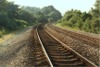
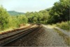
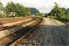
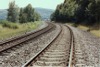
 bpm01570.jpg |
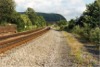
CAM | Cardiff (Bute Rd) & Merthyr | View looking up the valley towards Treforest at a location 18chains north of the former location of Taffs Well Siding signal box which controlled entrance to the Pentyrch railway to Melyngriffith works at Whitchurch. The barren trackbed on the left carried the up & down relief lines between Pontypridd & Radyr | Opposite Glanyllyn & south of down distant for Taffs Well signal box | 8 | 30 | East | 15-Jul-91 | 19.01 |
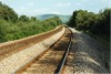
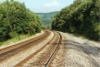
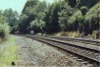
 bpm01571.jpg |
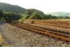
CAM | Cardiff (Bute Rd) & Merthyr | Reverse curves and transition in up & down main lines approximately six chains north of site of former Taffs Well Siding signal box | Opposite Glanyllyn, north-west of Taffs Well | 8 | 18 | SE | 15-Jul-91 | 19.03 |
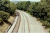
 bpm01572.jpg |
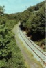
CAM | Cardiff (Bute Rd) & Merthyr | Up & down main lines and relief lines trackbed on 88-yard Taffs Well viaduct north of Taffs Well | Taffs Well viaduct, | 7 | 74 | West | 15-Jul-91 | 19.08 |
 bpm01573.jpg |
CAM | Cardiff (Bute Rd) & Merthyr | Up & down main lines and relief lines trackbed on 88-yard Taffs Well viaduct north of Taffs Well. The former A470 road overbridge between Taffs Well & Glanyllyn is seen in the distance | Taffs Well viaduct | 7 | 74 | West | 15-Jul-91 | 19.10 |
 bpm01574.jpg |
CAM | Cardiff (Bute Rd) & Merthyr | Reverse view of frame bpm01573.jpg, showing up & down main lines on Taffs Well viaduct which spans the river Taff | Taffs Well viaduct | 7 | 74 | East | 15-Jul-91 | 19.10 |
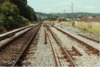
 bpm01575.jpg |
WVL | Park Jct & Aberbeeg Jct | Up and down main lines looking west at junction for Bedwas through single line to Machen Quarry (Left-hand branch). The ground disc controls movements to the Machen line, and the 3-ft arm controls movements to the Aberbeeg-Ebbw Vale line | West of Park junction, Newport | 1 | 09 | SE | 20-Jul-91 | 15.01 |
 bpm01576.jpg |
WVL | Park Jct & Aberbeeg Jct | Up & down main Western Valleys line, west of Park junction showing down homes bracket signal routing for Gaer line (GAE) and Cardiff Curve to Ebbw junction respectively | West of Park junction, Newport | 1 | 09 | NW | 20-Jul-91 | 15.01 |
 bpm01577.jpg |
WVL | Park Jct & Aberbeeg Jct | Up and down main lines looking west just beyond junction for Bedwas through single line to Machen Quarry. Turnout is a 1in11 Flat-bottom assembly. Note the single blade catch point in the Machen branch | West of Park junction, Newport | 1 | 10.5 | SE | 20-Jul-91 | 15.02 |
 bpm01578.jpg |
WVL | Park Jct & Aberbeeg Jct | Up & down main Western Valleys line, west of Park junction. The right single bi-directional line runs to Machen quarry and was part of the former Newport-Brecon via Bargoed line | West of Park junction, Newport | 1 | 14.5 | NW | 20-Jul-91 | 15.11 |
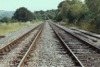
 bpm01579.jpg |
WVL | Park Jct & Aberbeeg Jct | View of single line section of Western Valleys line running from Lime Kiln junction and splitting into down & up lines west of Park Junction. The left-hand single line runs to Machen quarry. | West of Park junction, photographed from PJ76 colour-light signal | 1 | 41.5 | SE | 20-Jul-91 | 15.13 |
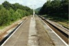
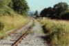
 bpm01580.jpg |
PEN | Halls Road junction & Markham Colliery | Single line at Thomas level crossing, Oakdale, taken a couple of months prior to the closure and lifting of the line | Thomas level crossing, Oakdale | 6 | 69 | South | 22-Jul-89 | 13.24 |
 bpm01581.jpg |
PEN | Halls Road junction & Markham Colliery | Looking southwards from Thomas level crossing at Oakdale, a couple of months prior to the closure and lifting of the line | Thomas level crossing, Oakdale | 6 | 68 | NE | 22-Jul-89 | 13.24 |
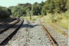
 bpm01582.jpg |
PEN | Halls Road junction & Markham Colliery | View of Thomas level crossing Oakdale taken immediately north of the crossing | Thomas level crossing, Oakdale | 6 | 70 | North | 22-Jul-89 | 13.26 |
 bpm01583.jpg |
PEN | Halls Road junction & Markham Colliery | View of singled Penar branch at Penmaen platform site prior to closure and lifting of the line. | Former Penmaen platform | 5 | 79 | West | 22-Jul-89 | 13.30 |
 bpm01584.jpg |
CAM | Cardiff (Bute Rd) & Merthyr | View looking north at a point where Pont Shon Norton signal box stood. Formerly a single line branch ran from the left at this location to terminate at a quarry south of Glyn Coch and also the single line Nelson branch ran to the right to pass over Berw viaduct and before closure, served Cilfynydd colliery | Former site of Pont Shon Norton signal box & junction | 13 | 60 | South | 22-Jul-89 | 14.40 |
 bpm01585.jpg |
CAM | Cardiff (Bute Rd) & Merthyr | Looking south from site of former Pont Shon Norton signal box and junction | Former site of Pont Shon Norton signal box & junction | 13 | 60 | North | 22-Jul-89 | 14.40 |
 bpm01586.jpg |
CAM | Cardiff (Bute Rd) & Merthyr | View of Merthyr lines north of Pontypridd station at the former Pontypridd Northern junction, looking south where a chord (Pontypridd Loop) interlinked the Treherbert branch through a cutting now backfilled. The cutting was just right of the milepost seen in the photograph | Former Pontypridd Northern junction & signal box (Pontypridd Loop) | 13 | 22.5 | NE | 22-Jul-89 | 14.58 |
 bpm01587.jpg |
CAM | Cardiff (Bute Rd) & Merthyr | Up & down Merthyr lines at B4273 road overbridge , Pont Shon Norton, north of Pontypridd | Berw Rd/Ynysybwl Rd overbridge between Pontypridd and Clydach Court | 14 | 10 | South | 22-Jul-89 | 15.13 |
 bpm01588.jpg |
CAM | Cardiff (Bute Rd) & Merthyr | Up & down Merthyr lines at an accommodation overbridge south of Glyn Coch | Unclassified accommodation road overbridge to Berwydd Dy Cottages, south of Glyn Coch & Clydach Court | 14 | 50 | South | 22-Jul-89 | 15.17 |
 bpm01589.jpg |
CAM | Cardiff (Bute Rd) & Merthyr | Up & down Merthyr lines looking towards Pontypridd from south end of Former Stormstown sidings and Ynysybwl branch (Right) | South of former Stormstown signal box | 15 | 30 | North | 22-Jul-89 | 15.27 |
 bpm01590.jpg |
CAM YNL |
Cardiff (Bute Rd) & Merthyr and Ynysybwl | Up & down Merthyr lines and approximate site of former Stormstown signal box (left at 15M-41C) and sidings. A junction for the single line to Nelson & Llancaiach formerly existed on the right at 15M-44C. This linked the Cilfynydd section of the Nelson branch and incorprated the colliery network. The left line was part of the now lifted Ynysybwl branch | South of former Stormstown signal box | 15 | 30 | South | 22-Jul-89 | 15.27 |
 bpm01591.jpg |
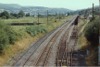
CAM | Cardiff (Bute Rd) & Merthyr | Up & down Merthyr lines and part of former Stormstown sidings up & down sidings | Unclassified road overbridge at Carnetown, South of Abercynon | 16 | 00 | North | 22-Jul-89 | 15.31 |
 bpm01592.jpg |
CAM | Cardiff (Bute Rd) & Merthyr | Up & down main lines with down through relief line (right) immediately south of Abercynon station & signal box | Unclassified road overbridge at Carnetown, South of Abercynon | 16 | 00 | SW | 22-Jul-89 | 15.31 |
 bpm01593.jpg |
CAM YNL |
Cardiff (Bute Rd) & Merthyr and Ynysybwl | View from the now lifted Ynysybwl branch (left) looking north towards Stormstown sidings & up & down Merthyr/Aberdare lines | North of Cwm viaduct near Clydach Court | 15 | 10 | South | 23-Jul-89 | 09.05 |
 bpm01594.jpg |
CAM YNL |
Cardiff (Bute Rd) & Merthyr and Ynysybwl | View from the now lifted Ynysybwl branch (right) looking south towards Stormstown sidings and up & down Merthyr/Aberdare lines. The 55-yard Cwm viaduct at 15M-10C, is just visible on the main line curve beyond the colour-light signal | North of Cwm viaduct near Clydach Court | 15 | 15 | North | 23-Jul-89 | 09.10 |
 bpm01595.jpg |
YNL | Ynysybwl | View of out-of-use Ynysybwl branch at a location near the former Clydach Court loop junction which originally connected directly with a chord to the Pontypridd-Abercynon section at Clydach Court Junction | Road overbridge at Clydach Court | 14 | 70 | SW | 23-Jul-89 | 09.16 |
 bpm01596.jpg |
VON | Neath (General) & Pontypool Road | View of remaining sidings and through line to Tower Colliery on the former Vale of Neath branch | Aberdare High Level yard (Footbridge) (Former Gadlys junction) | 22 | 68 | NW | 23-Jul-89 | 09.43 |
 bpm01597.jpg |
VON | Neath (General) & Pontypool Road | View of curtailed sidings and through singleline to Tower Colliery on the former Vale of Neath branch | Robertstown footbridge (Approx former Gadlys junction site) | 22 | 68 | SE | 23-Jul-89 | 09.43 |
 bpm01598.jpg |
VON | Neath (General) & Pontypool Road | Singled former double Vale of Neath branch at Wellington Street level crossing. Roberstown, Aberdare, looking towards Hirwaun | Wellington Street level crossing (Robertstown) Aberdare | 23 | 08 | SE | 23-Jul-89 | 09.47 |
 bpm01599.jpg |
MER | Merthyr & Gelli Tarw junction | View from B4276 Road overbridge, of former Llwydcoed station site, The trackbed is now a public leisure walk | Former Llwydcoed Station (5M-44C from Merthyr) | 0 | 60.5 | South | 23-Jul-89 | 09.53 |
 bpm01600.jpg |
VON | Neath (General) & Pontypool Road | View from newer Heads of the Valleys road overbridge est of Hirwaun and looking east towards site of former Gelli Tarw junction | Heads of Valleys road overbridge near Hirwaun | 25 | 10 | West | 23-Jul-89 | 09.59 |
|
Photos 1551-1600 |
|||||||||
|
Date Last Revised:November 30, 2009 |
|||||||||